PhotoGeo Trip Down East: Part 5 – Cape Breton Highlands
2,283 words, 12-minute read time.
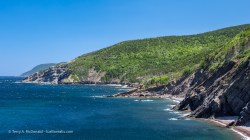
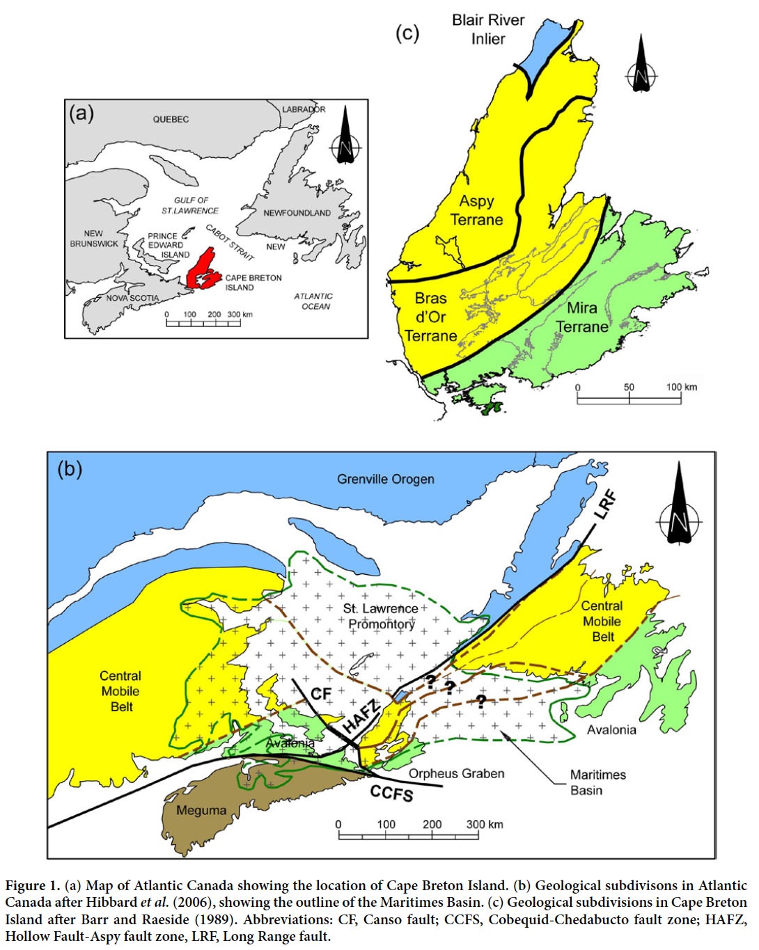
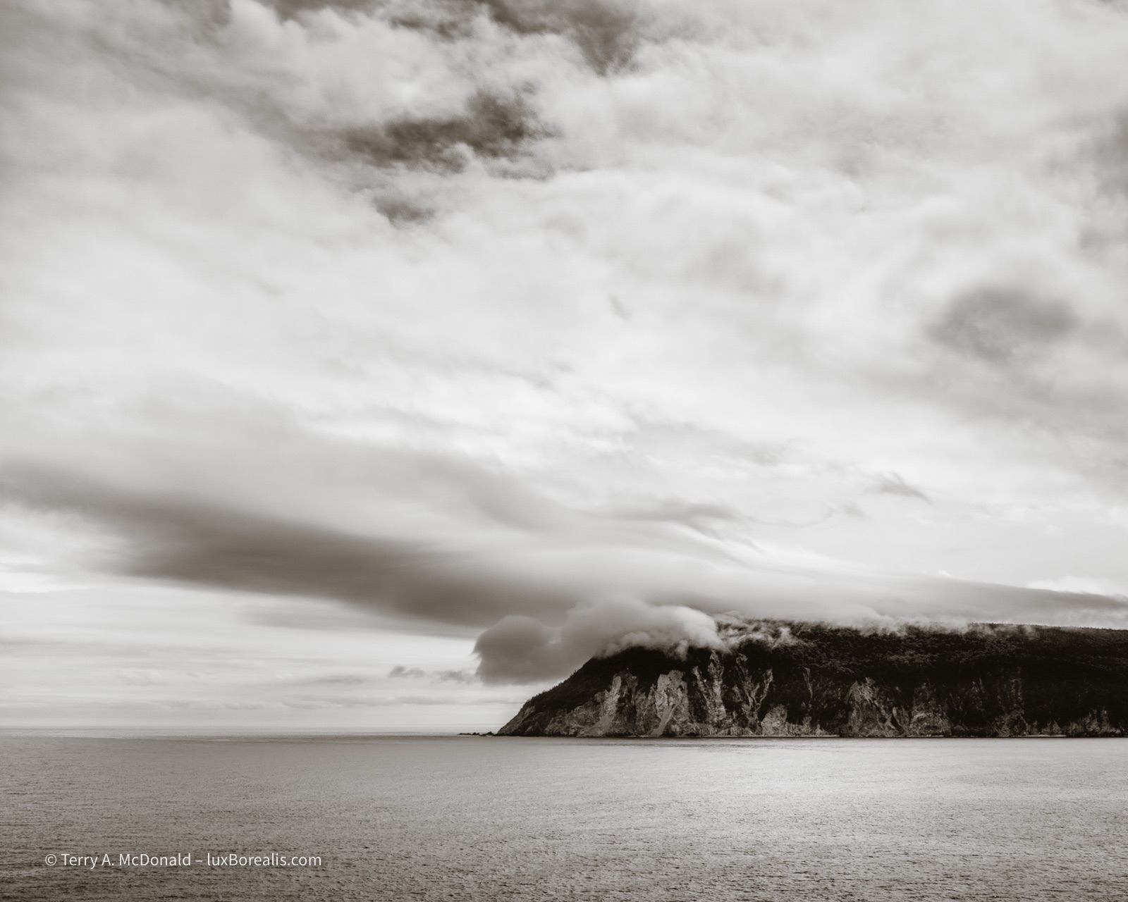
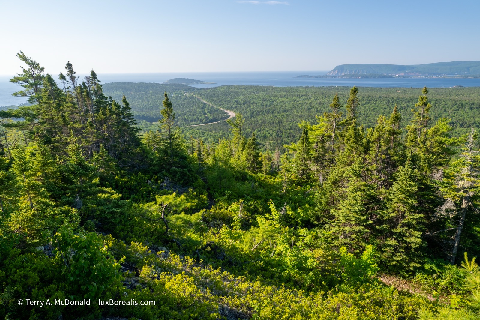
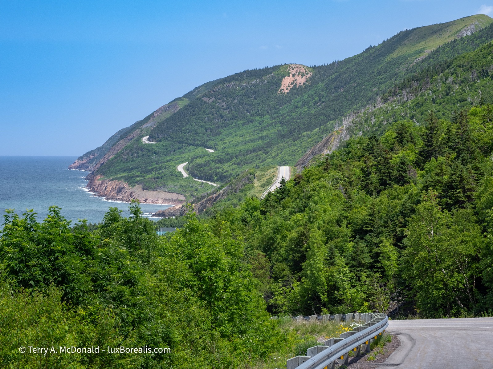
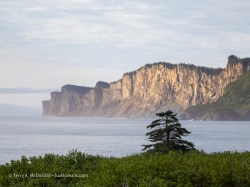
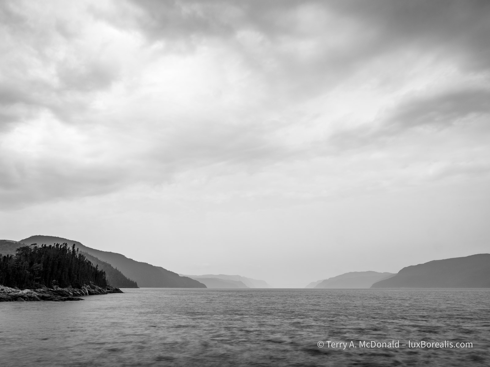
Wow! I’d forgotten how beautiful the Cape Breton Highlands are: steep-sided, glaciated flat-topped hills with deep valleys, green with mixed forests plunging down into an ocean so clear and blue. Geologically it’s a smorgasbord of pieces of Earth’s crust jammed together over the last billion years: ancient Canadian Shield in the northwest from the formation of the Laurentians; part of a volcanic belt formed off South America in the centre; and a section of a volcanic belt from what is now North Africa in the southeast; along with a smattering of granitic plutons from 500mya.
an overview
As Captain Kirk would say, ‘Fascinating, Jim.’
Okay, I know, TMI. But you must admit that it’s cool to be at the epicentre of where the North American plate and the Eurasian Plate and the African Plate repeatedly smashed together to form first the supercontinent of Rodinia, then the supercontinent of Pangaea and the Appalachian Mountains, with all these bits of continents and volcanic arcs thrown in for good measure, followed by the subsequent rifting, about 200mya that produced what is now the Atlantic Ocean. Yes, truly fascinating. A billion years worth of continental drift in one sentence! FMI, see Parks Canada’s excellent web page describing these processes. Or, try it yourself at this website—simply enter ‘Sydney, Nova Scotia’ and use your cursor keys to navigate through time.
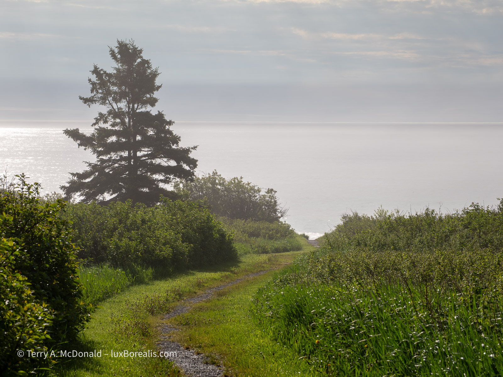
OM-1 | 20mm+POL | ƒ5.6 @ 1/200 | ISO 200 | HHHR | Raw | Lightroom
After all the crashing around of plates, this scene is simply bucolic.
But what does this have to do with photography?
I’m making landscape and nature photographs. I simply can’t divorce the geography and geology from what I’m seeing and what I’m making of what I see. Both the landscapes and the photographs somehow feel more real when I can connect the natural processes going on around me with the images I’m making—and vice versa.
Of course, the objective viewer couldn’t care less (other than Geo-Geeks like me, my wife Laura, and my friend Dan with whom I started this journey a few weeks ago). In other words, in the minds of the viewing public, the processes that formed the landscapes are irrelevant. Yet, being informed and interested about how these places came to be may just be the little extra that helps me to ‘see’ the photographs I’m working to create.
Made after sunset using LiveND
OM-1 | 12mm | ƒ4 @ 0.8sec | ISO 800 | Raw | Lightroom
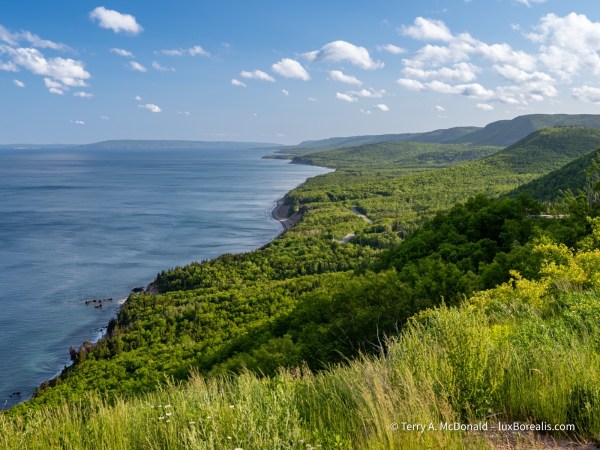
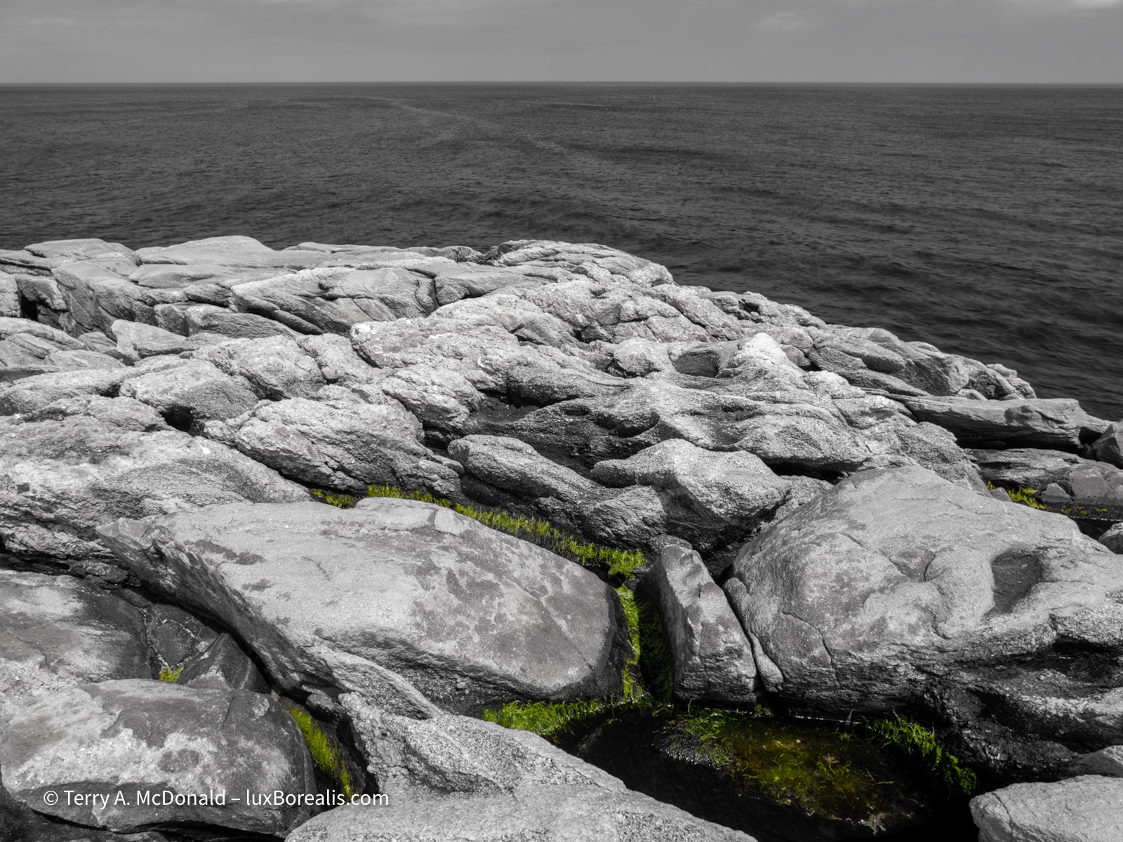
Change is still happening as the landscape is further weathered and eroded, day-in, day-out, year-in, year-out.
I’m making portraits of Earth. The first rule of making intimate portraits is to know your subject. Celebrated Canadian portrait photographer Yousef Karsh knew this well. ‘Yousef Karsh?’ you ask. Whether you’re shooting landscapes, nature or portraits, his work, his methods and his career are all well worth studying. Not only that, but as an addendum to my previous post, Africville, Karsh was a refugee from the Armenian genocide, arriving in Halifax in 1923 at the age of 15 and went on to become a portrait photographer sought by the well heeled the world over. Fascinating!
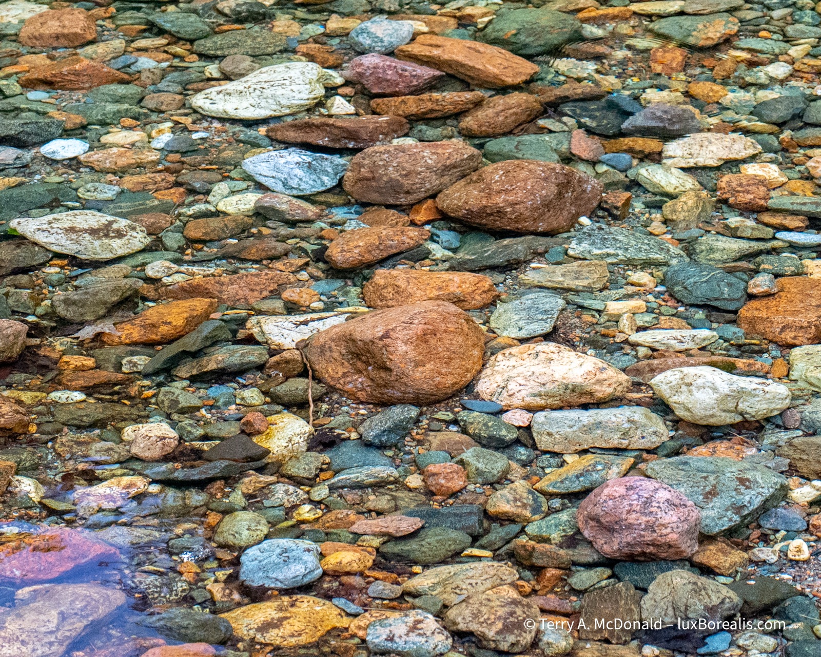
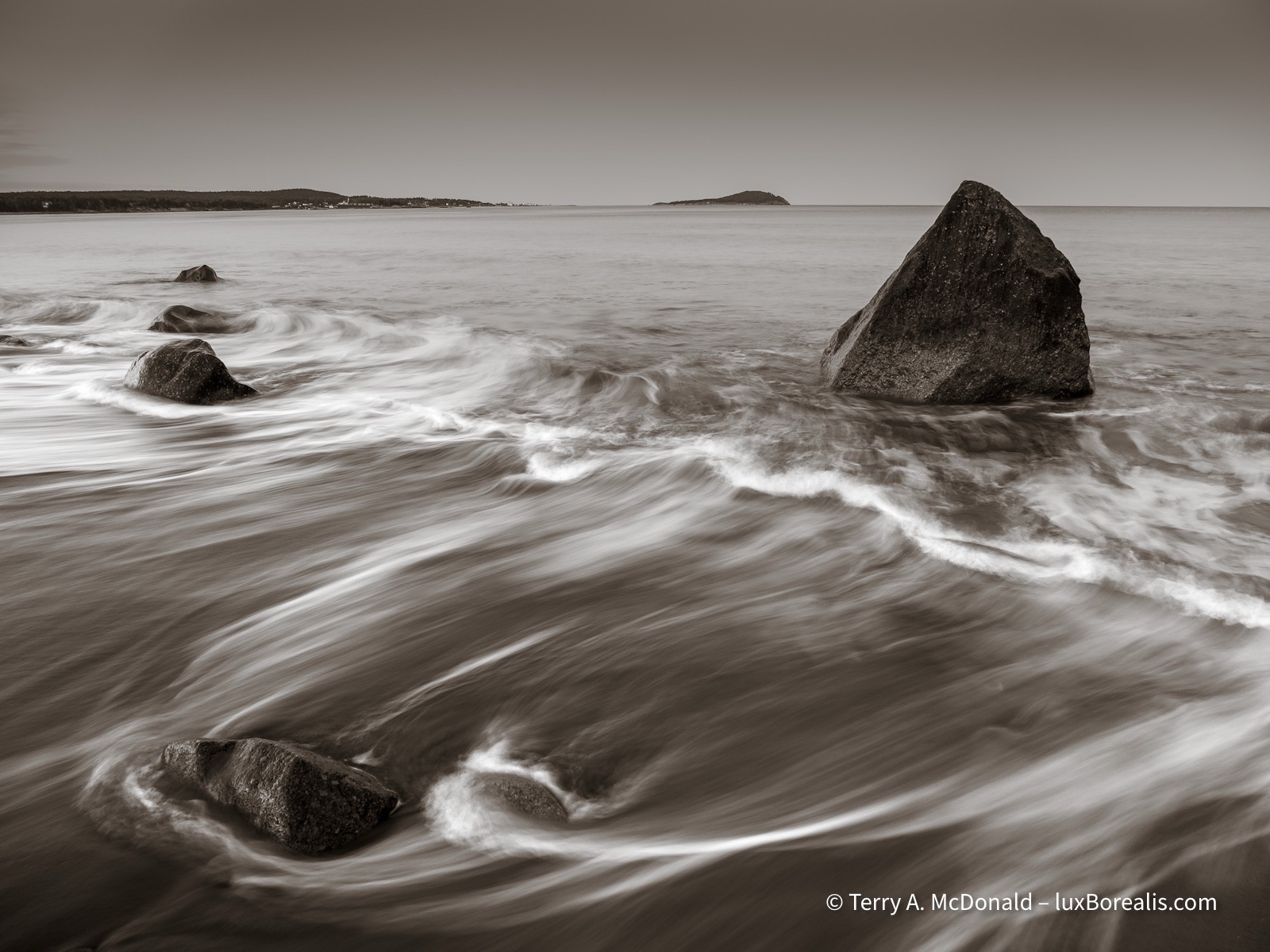
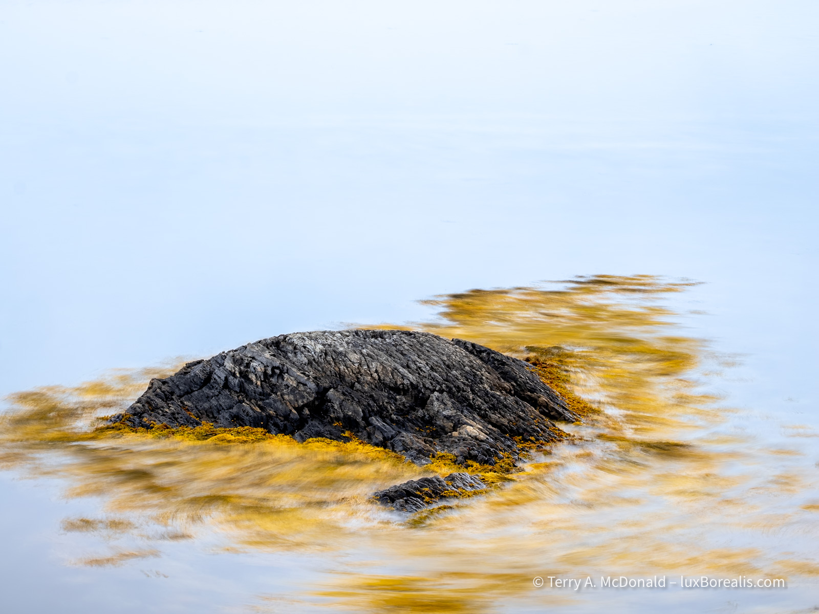
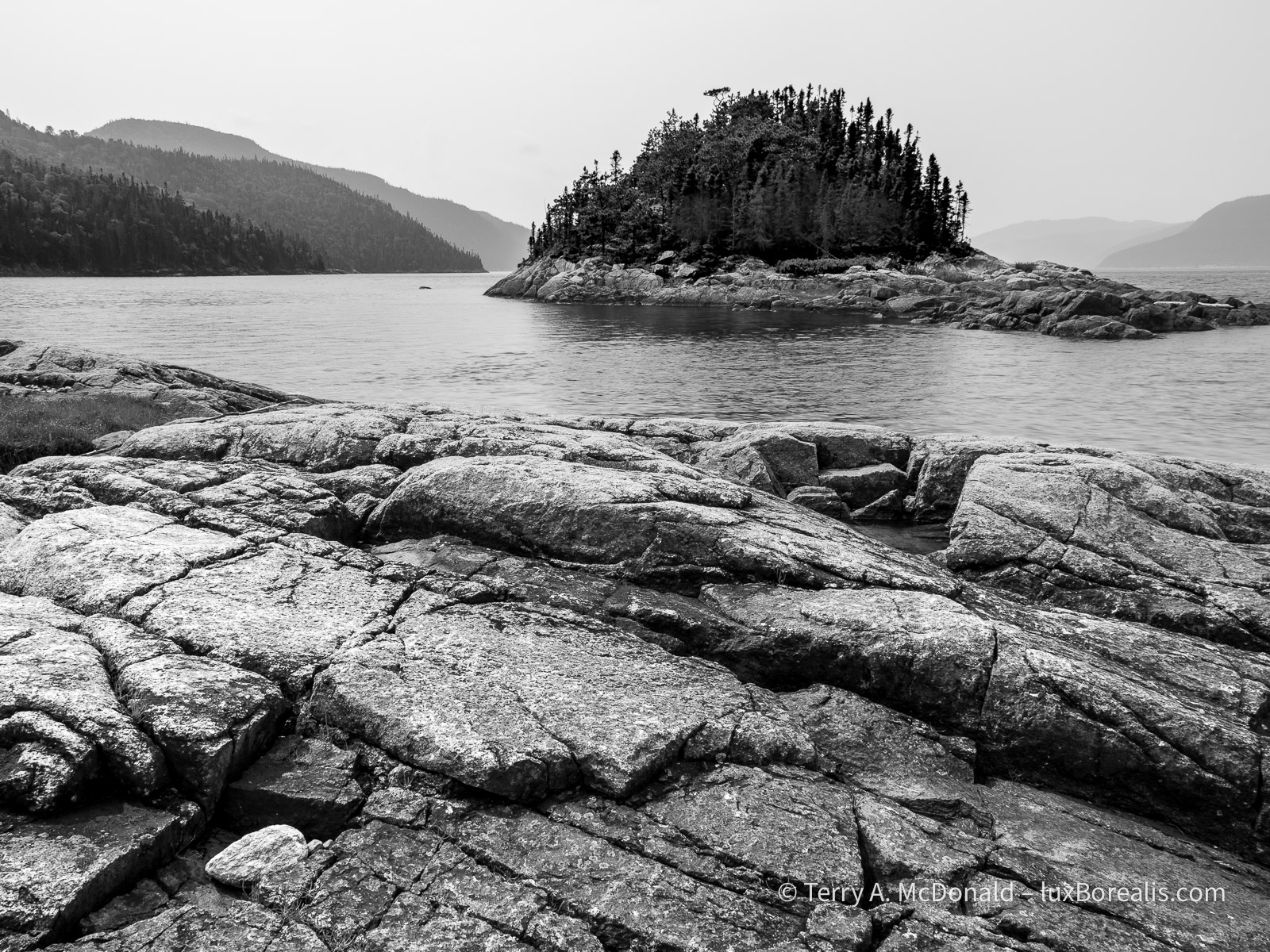
The kaleidoscope of colours reflects the very long and tumultuous journey these rocks have made over the last 500 million years.
OM-1 | 47mm+POL | ƒ5.6 @ 1/250 | ISO 3200 | Raw | Lightroom
Perhaps it’s my Scottish blood that causes this place to resonate with me, as it did with the earliest Scottish settlers. Tossed off their land by the English during the Highland Clearances, they ended up here in Cape Breton and to them it not only felt like home , but it looked like home too. Funny thing is, that was before anyone realized that, in fact, much of Cape Breton Island is made of the same stuff as the Scottish Highlands before the formation of the Atlantic. Yes, truly fascinating!
Astrophotography
On our first night in Cape Breton, I (finally) had an opportunity to work on some astrophotography. At 1:30am I headed down to the beach with my tripod, my folding chair and equipment—OM-1 with the Leica DG Summilux 9mm/1.7 on, and an extra battery. I didn’t bother to attach the HLD-10 Battery Grip. Given the chill temperature, the core and sensor wouldn’t heat up too much from battery drain.
Having scouted the location earlier in the evening (see Wave Wash I above), I had a few ideas of where to set up. Upon reaching the beach, I was greeted with a very obvious Milky Way arcing up from the south. Wow! With crystal clear skies, and the temperature a chilly 6°C—the conditions were perfect for a million billion stars.
The trouble, as always, was with lights. Along the coast, they are unavoidable except in the most remote places, and at 1:30 in the morning, I didn’t feel like more driving after a day of it. Oh well, ‘Do the best with what you’ve got.’
From my earlier practice session, I knew ƒ2 @ 15sec would work very well, as the shutter speed was below the ‘400 Rule’ limit (400 ÷ focal length in 35mm terms; for me 400 ÷ 18 = 22 sec.) Note: in the same blog post, I list all the settings I use for Astrophotography.
After my first exposure, I was thinking ‘Wow!’, again. Except for a few adjustments (like remembering to not just set Starry Sky AF, but to activate it as well!—duh!), the photo was bang on, using ISO 3200. I was confident that any noise at that ISO would be beautifully cleaned up in Lightroom. Note: if you haven’t recently used Lightroom’s Enhanced NR, you’re in for a treat as now it’s built right in to the raw processing workflow so a separate DNG file is no longer produced. Wonderful!
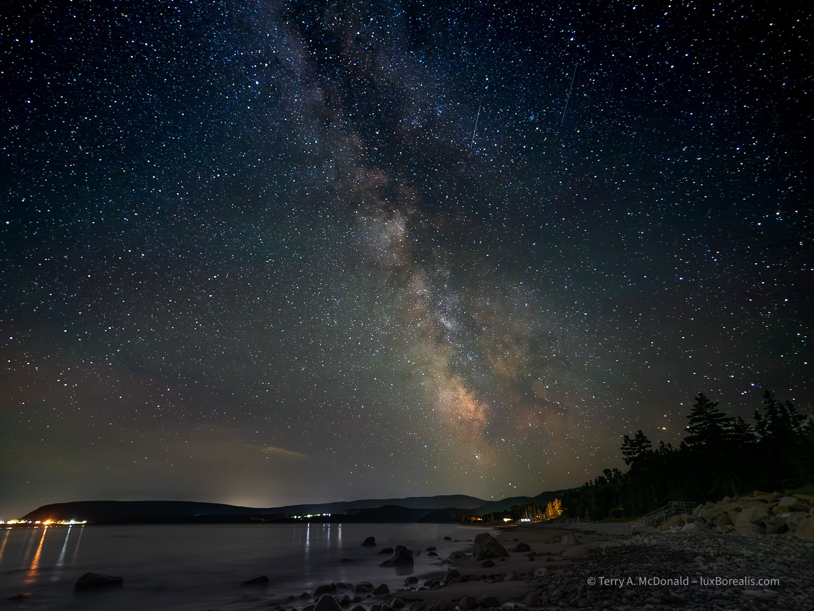
OM-1 | 9mm | ƒ2 @ 15sec | ISO 3200 | Raw | Lightroom
My preferred image, though, is a vertical:
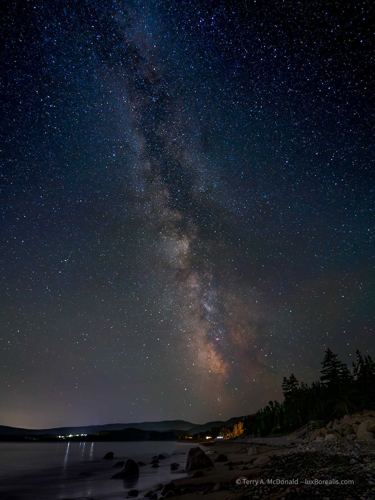
OM-1 | 9mm | ƒ2 @ 15sec | ISO 3200 | Raw | Lightroom
One thing I didn’t do, was to make multiple images that could later be combined into a single image. This improves image quality and allows for a separate image of the foreground to provide better balance with the star exposure. However, that said, astrophotography is a work in progress with me and I am very pleased with the results.
My next undertaking was to weather the cold and make a LiveComposite image. Again lights plagued the view. As I looked over my shoulder I noticed the striking orange crescent of the waxing moon rising just above the horizon. It is this brightening glow that is captured along the eastern (right) horizon of the next photograph. Some of the glow is also from the pre-dawn glow of sunrise, which is at 5:09am (!!), less than 2 hours from when the photo was made.
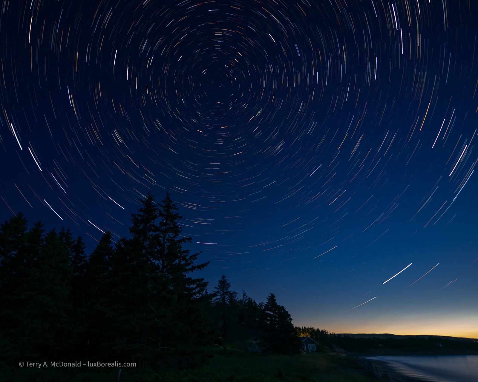
OM-1 | 9mm | ƒ2 @ 30x60sec | LiveComposite | ISO 3200 | Raw | Lightroom
The novel I was reading while waiting (iPhone in dark mode!) helped to take my mind off the cold, but after 30 minutes the star trails looked good, and I was shivering. I’m not at the point of leaving my gear and going back to warmth then coming back an hour or so later. Perhaps that will happen once I’m in a place without anyone else around. I know, ‘Who’s up at 3am?’. Still . . .
OM-1 | 20mm+POL | ƒ8 @ 1/500 | ISO 200 | HHHR | Raw | Lightroom
Almost
Is it possible to have conditions too perfect for photography? For the last couple of days, I’ve felt this pull to make some significant photographs in this place that has such an amazing geography and geology, but I’m failing.
The days have been beautiful summer days. Sunny for the most part, and I mean brilliant sunshine from dawn to dusk—great for those ‘on vacation’, but not ideal for landscapes. Blank skies just don’t cut it and, no, I don’t ’swap skies’, the latest rage in AI photography.
OM-1 | 12mm+POL | ƒ8 @ 1/250 | ISO 200 | HHHR | Raw | Lightroom
So, for the last few days, I’ve feel like I’ve been making a series of ‘almosts’. The light is almost right. The waves are too tame. My compositions are almost there. I’m almost close enough.
OM-1 | 14mm+POL | ƒ8 @ 1/800 | ISO 800 | Raw | Lightroom
Also, I’m kicking myself for not paying closer attention to the limitations of HHHR with moving water. I knew faster shutter speeds were a problem as they show a ‘chattering’ pattern with moving highlights. I have a dramatic low-key photo of a rock fall along the coast, shot at 1/50, which produced chattering wave wash. Chalk it up to experience, I guess. I should have used LiveND or, when using HHHR, thrown on an ND filter.
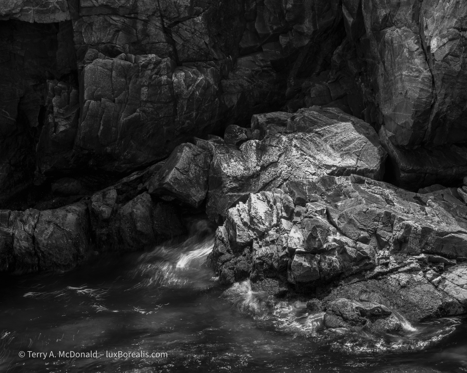
OM-1 | 57mm+POL | ƒ8 @ 1/50 | ISO 100 |HHHR | Raw | Lightroom
A slow shutter speed should blur the water when used with HHHR, but the shutter speed is not slow enough, leaving a ‘chatter’ pattern in some of the highlights.
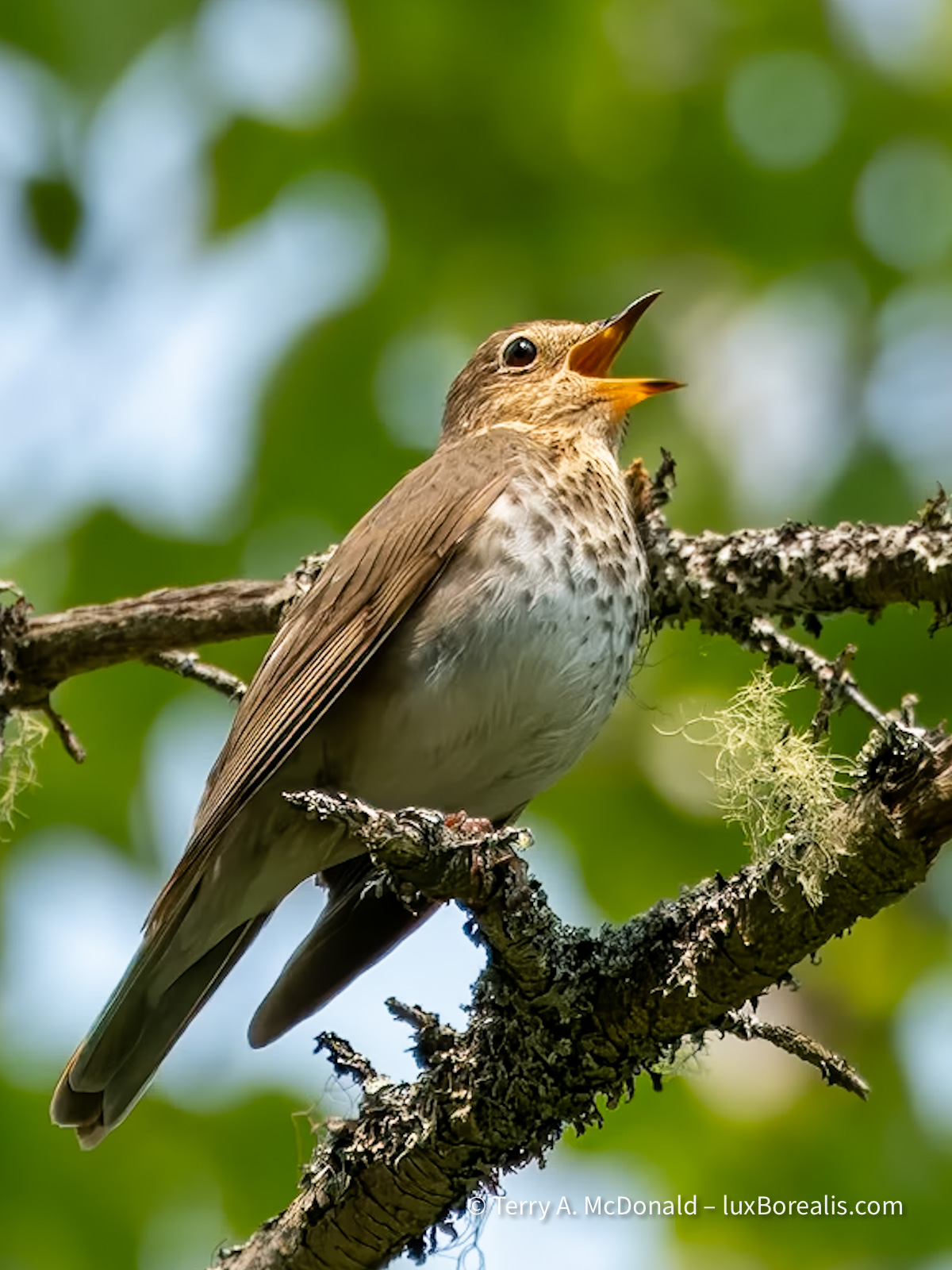
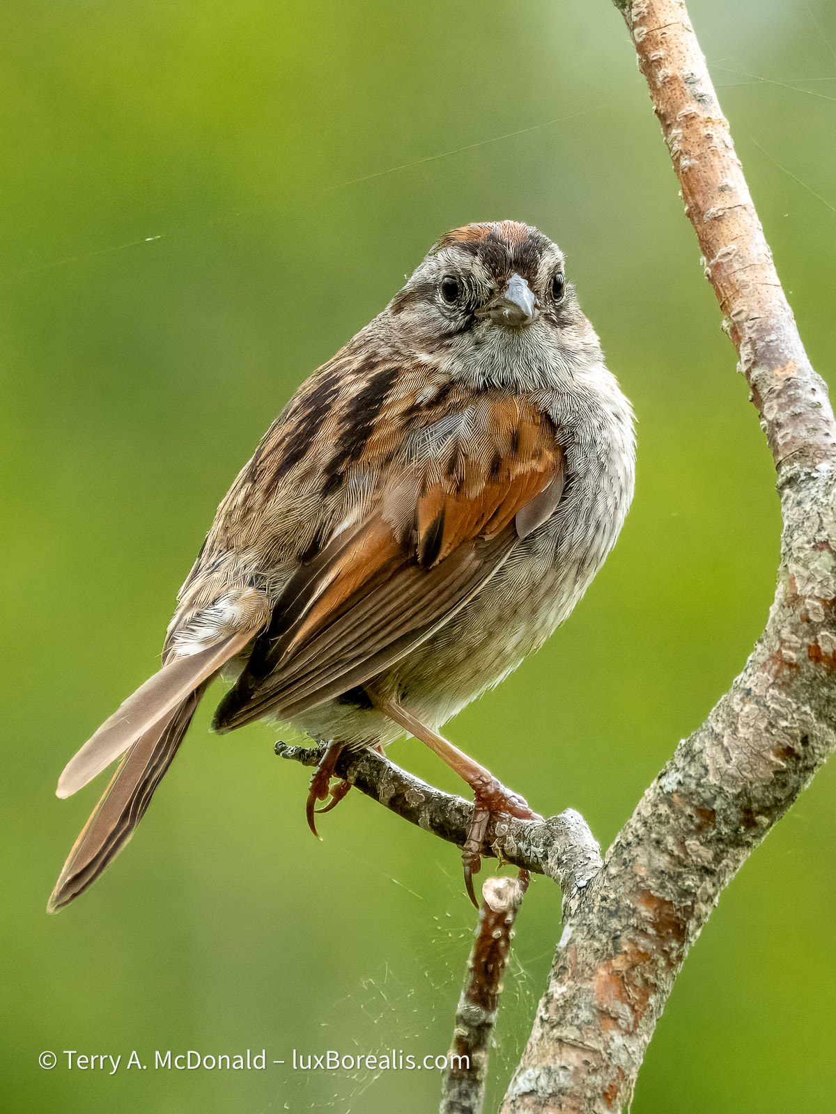
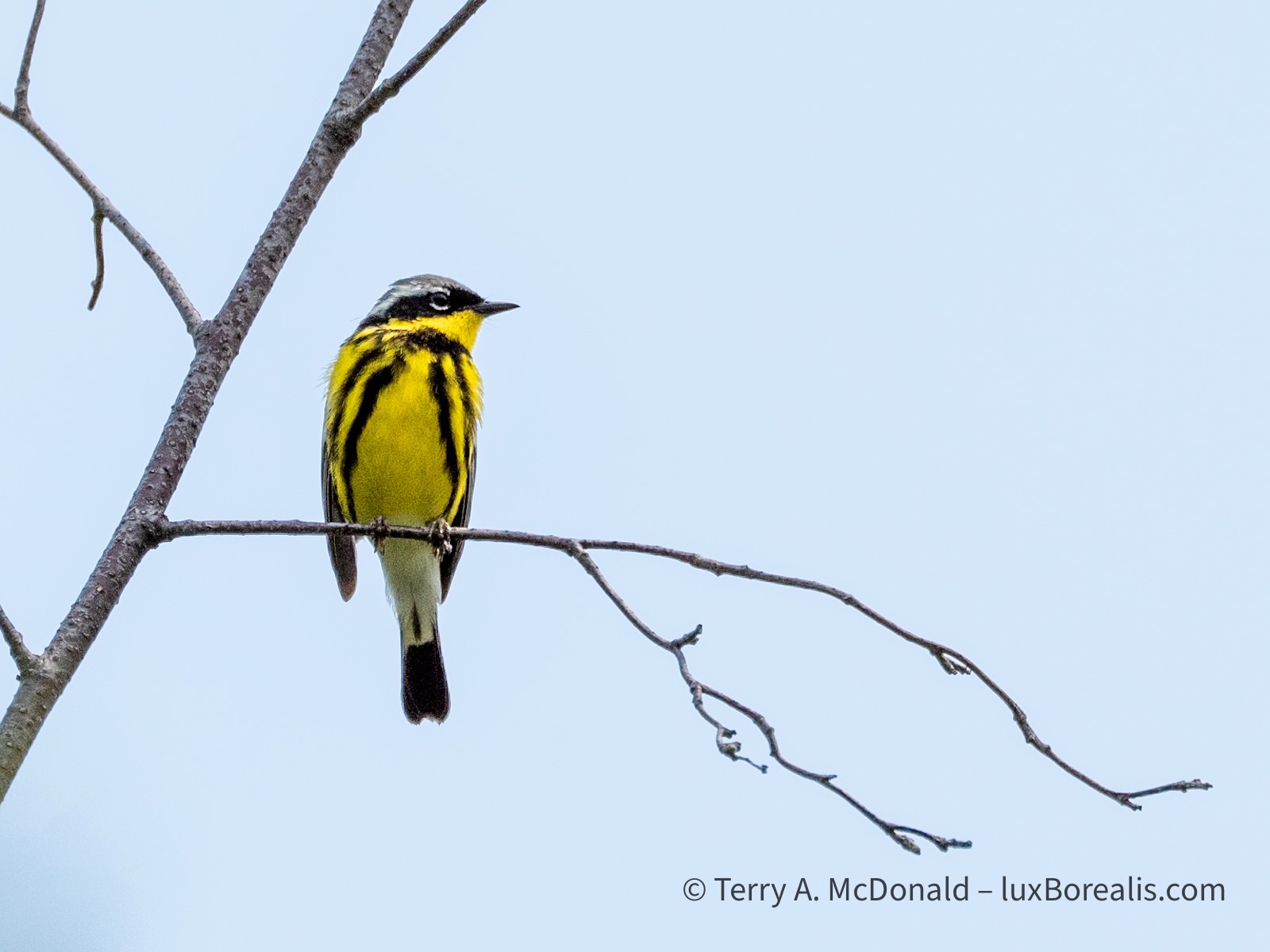
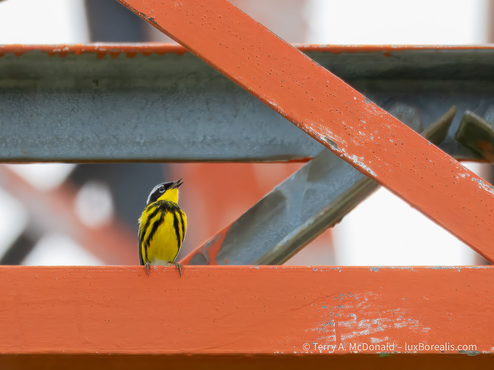
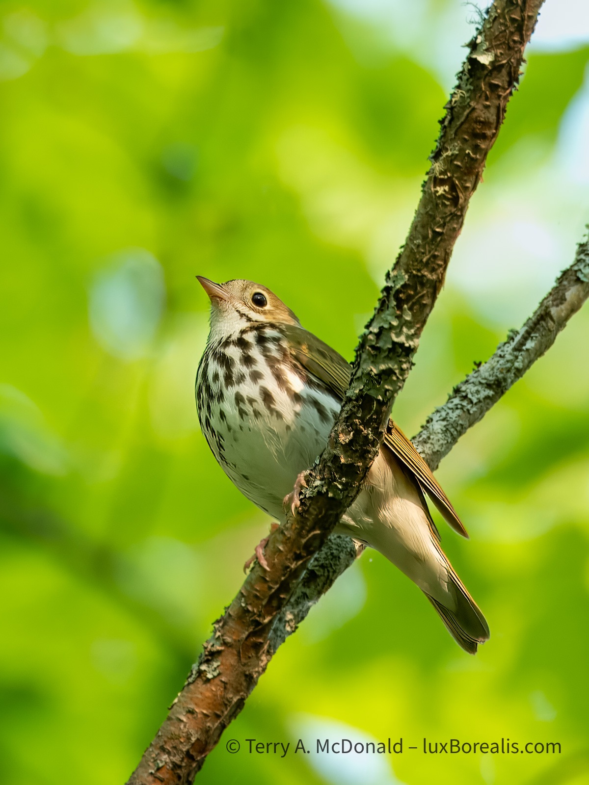
But there were many places and views to celebrate. With my daughter’s get up and go, we hiked up Broad Cove Mountain early one gorgeous morning—a 20-minute constant uphill for which we were awarded not only this great view, but the continuous and melodic call of a Hermit Thrush.
OM-1 | 12mm+POL | ƒ5.6 @ 1/500 | HHHR | ISO 800 | Raw | Lightroom
OM-1 | 60mm+POL | ƒ8 @ 1/320 | ISO 800 | Lightroom
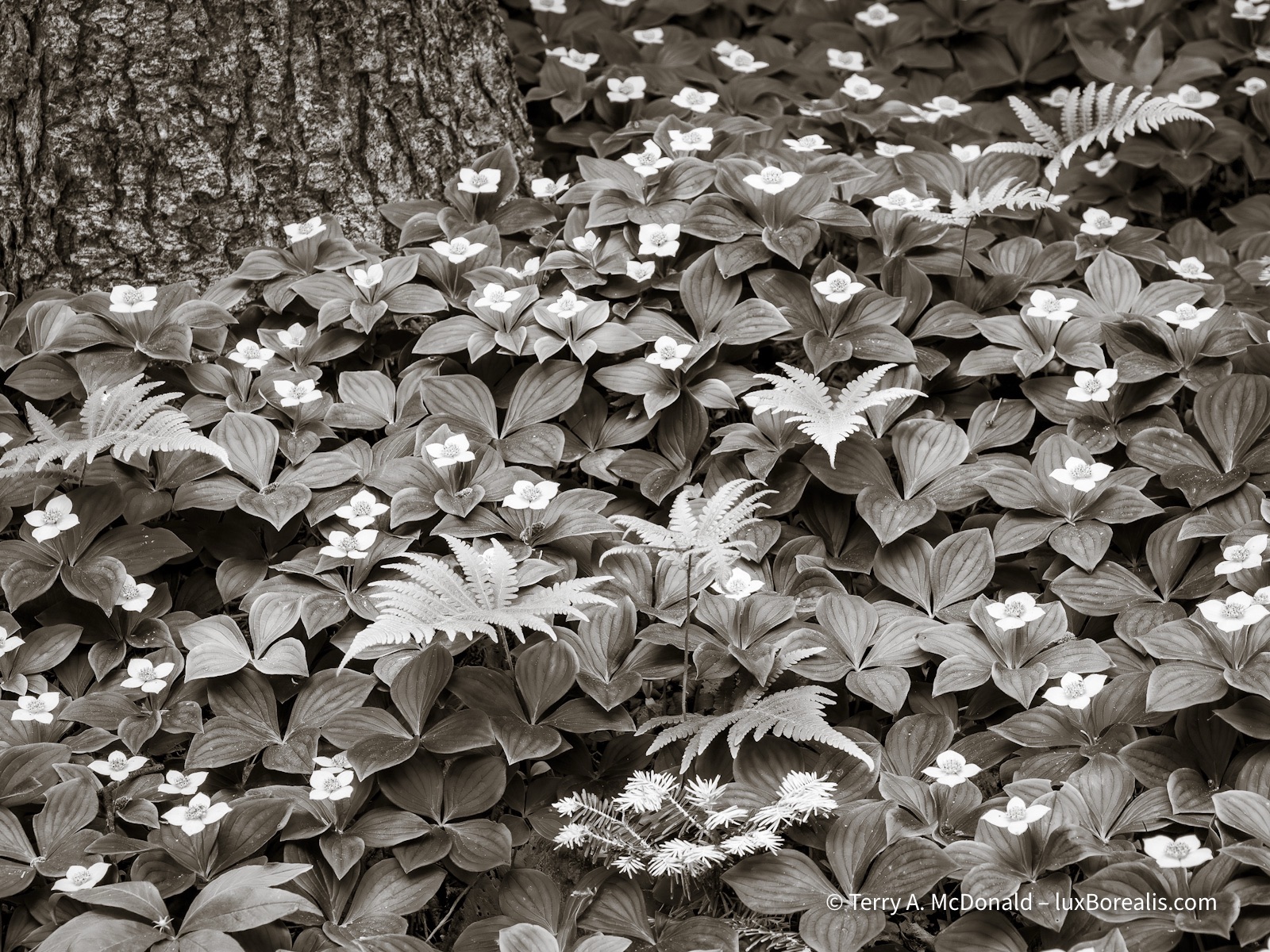
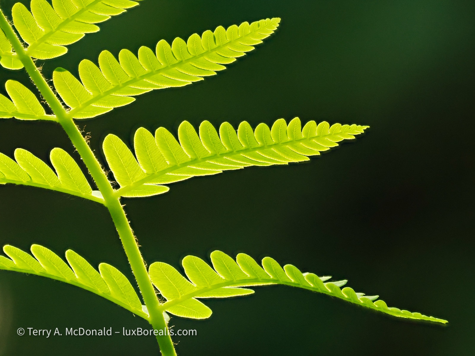
Bunchberry (Cornus canadensis) and various ferns carpeted the wooded slopes of Middle Head.
We made trips up to the north end of Cape Breton, to Bay Saint Lawrence and Meat Cove and around to the even more dramatic western coast. But even with the direct wind across the Gulf of St. Lawrence, the rollers coming ashore at Meat Cove, were not the dramatic crashing waves that would have added to this photo.
OM-1 | 75mm+POL | ƒ5.6 @ 1/250 | HHHR | ISO 200 | Raw | Lightroom
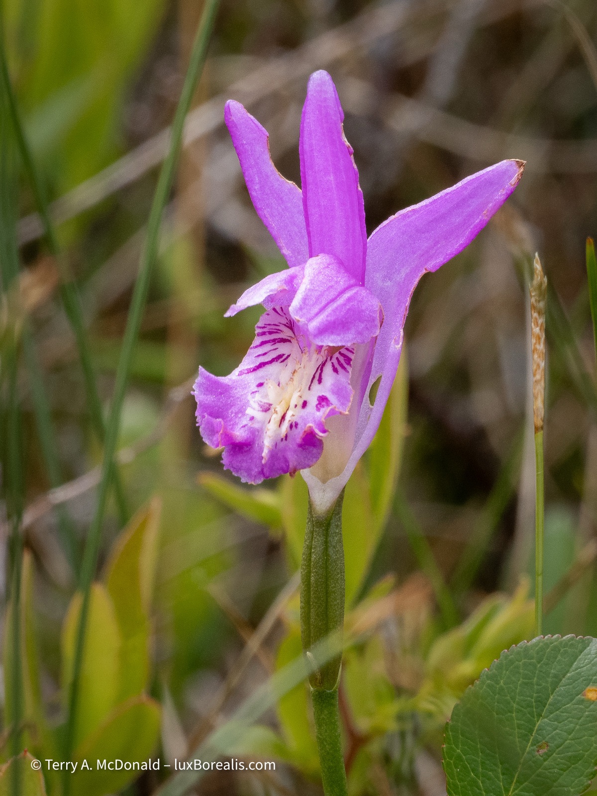
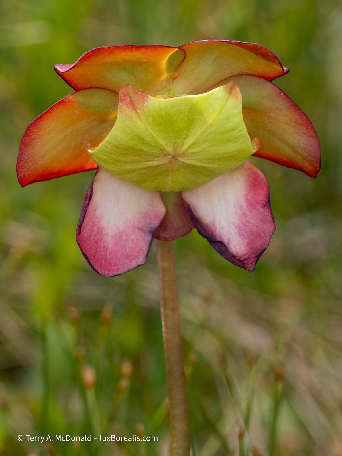
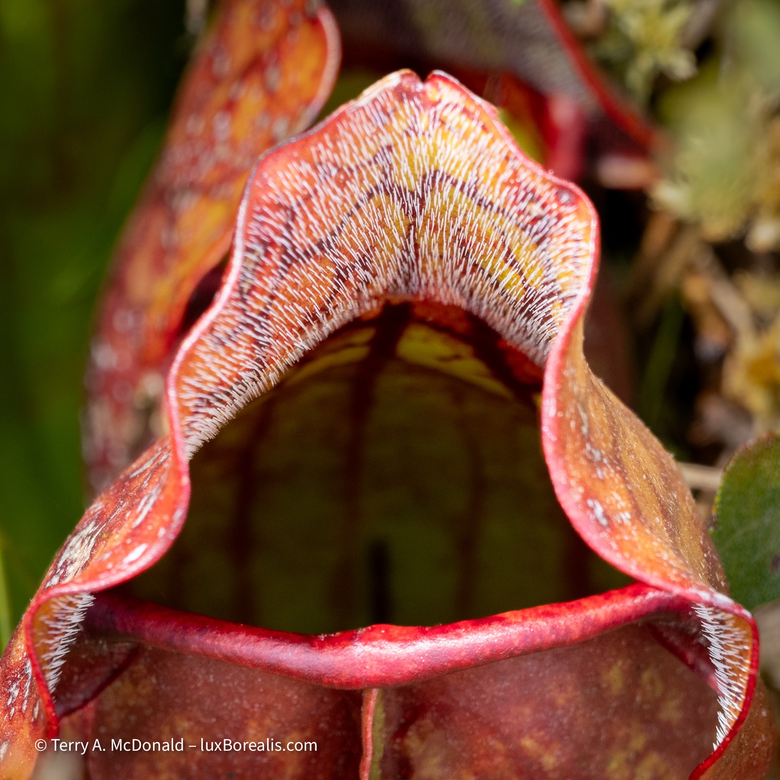
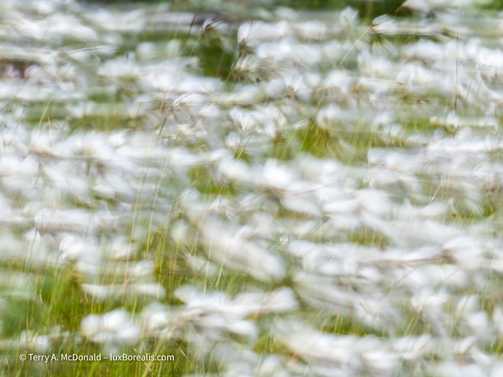
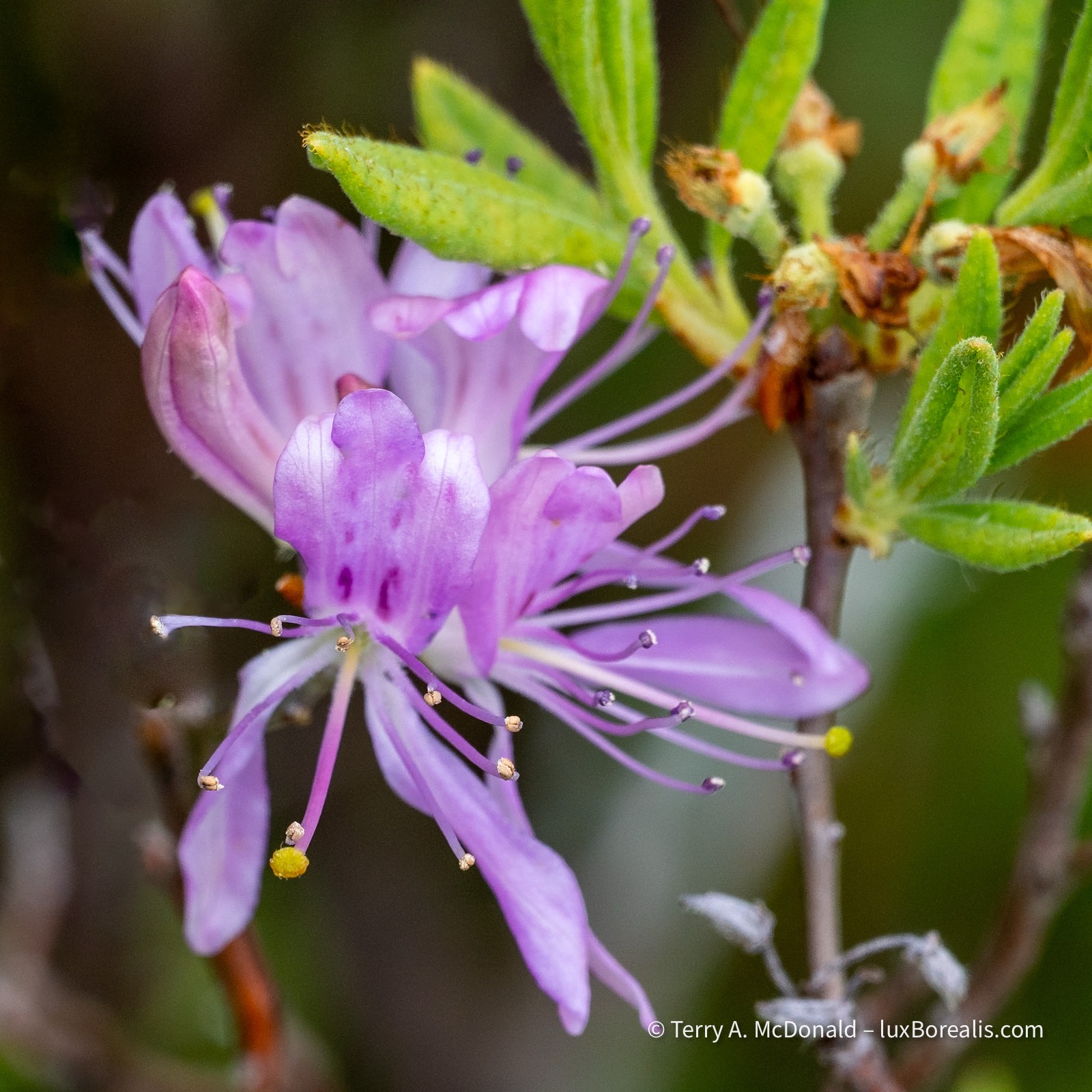
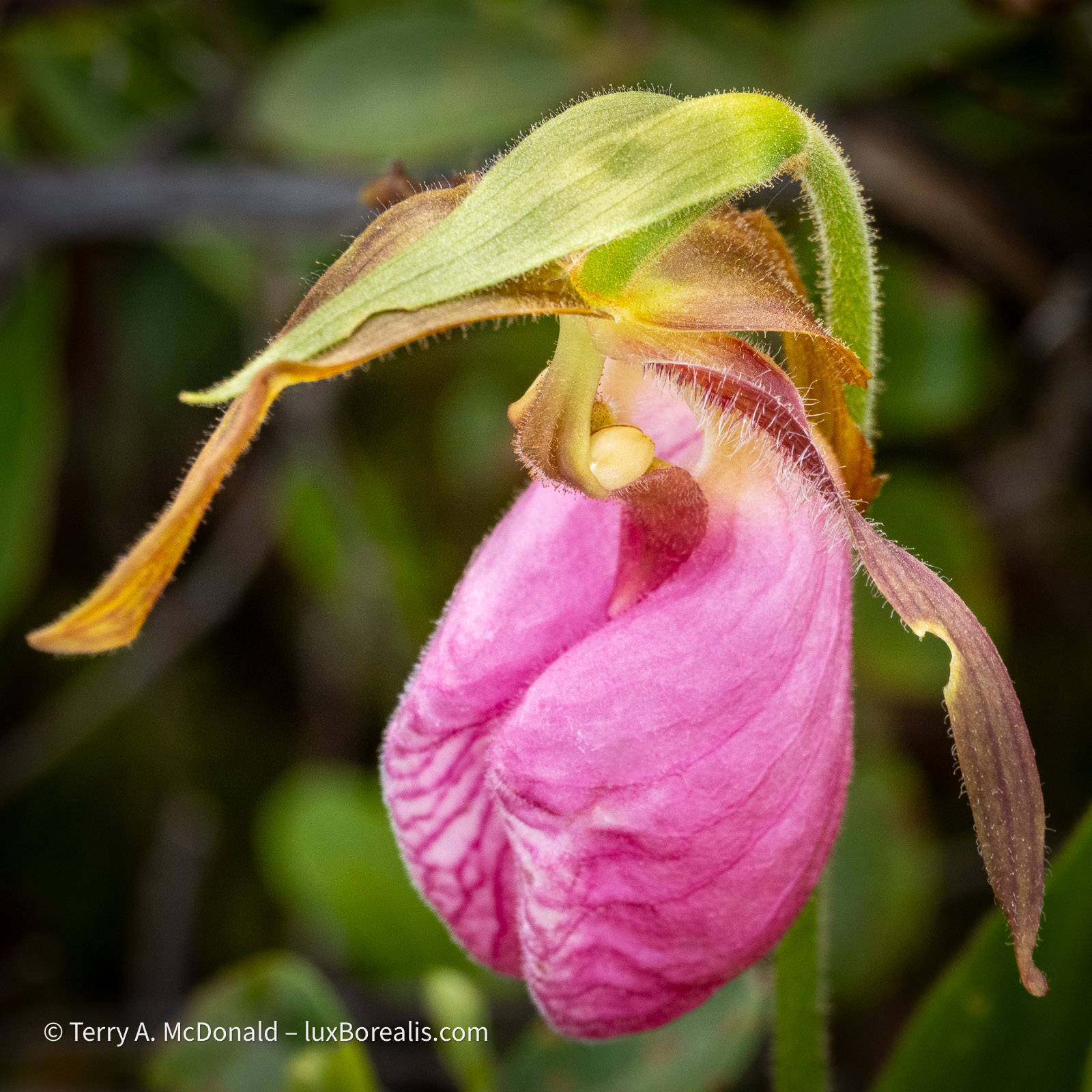
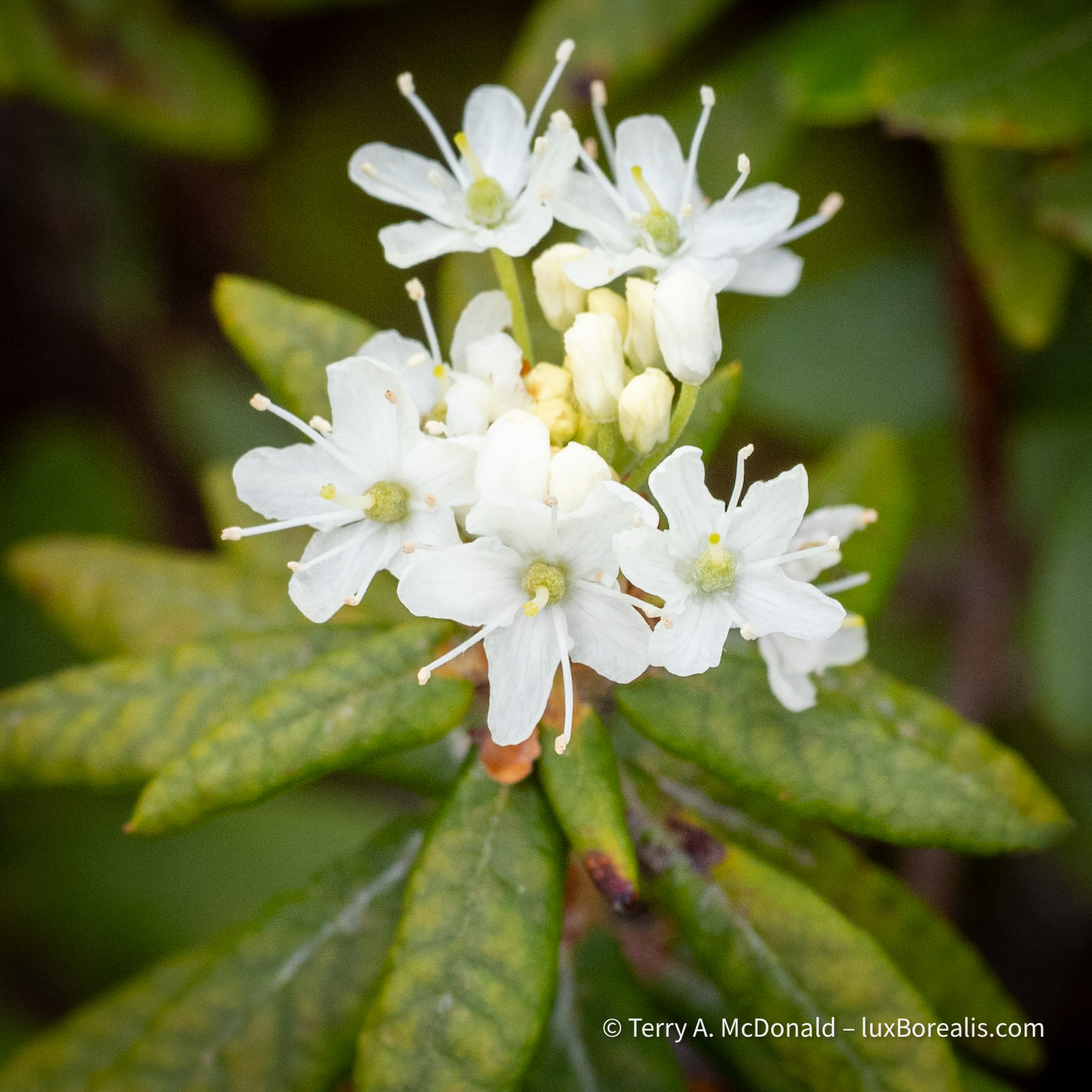
French Mountain Bog
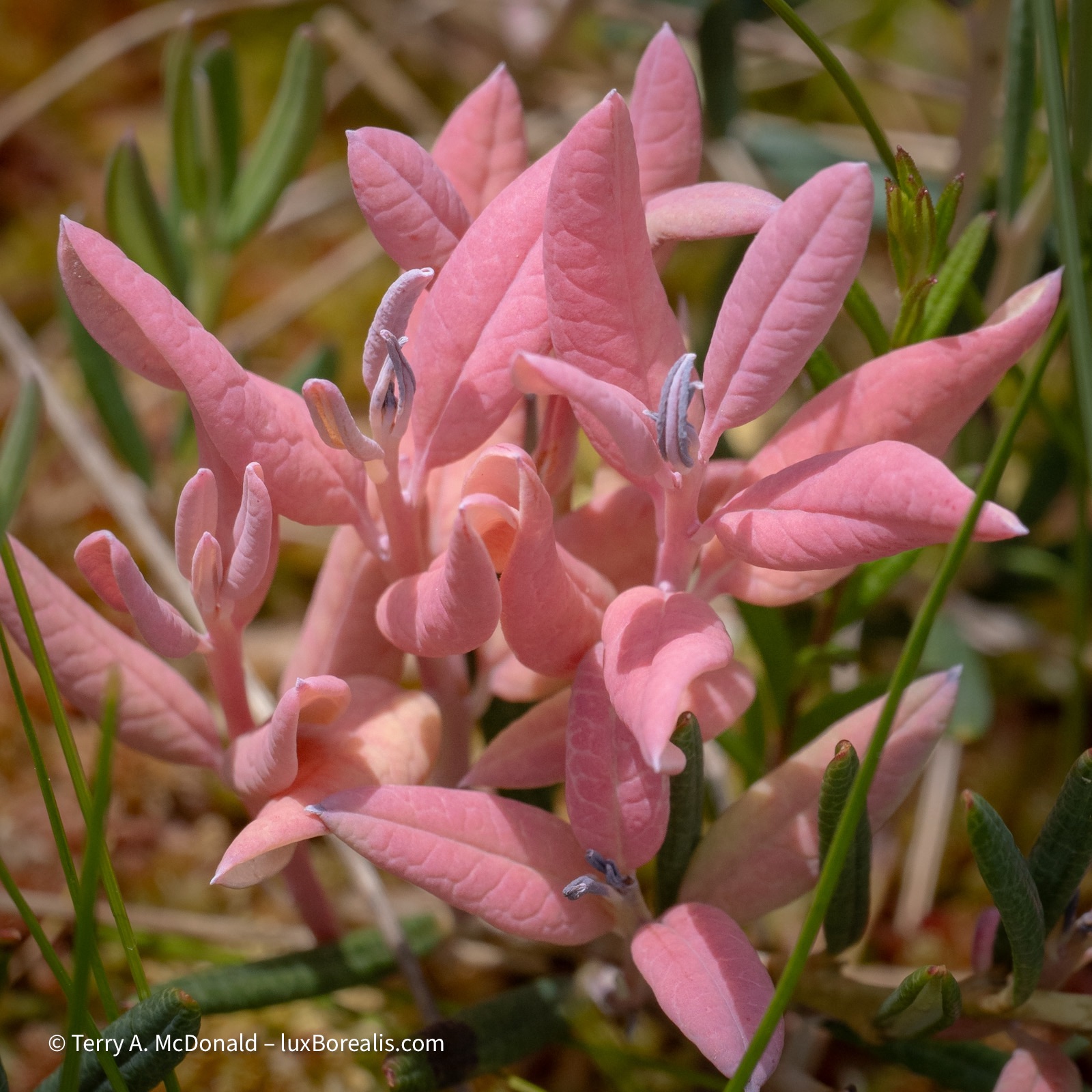
Always a highlight is a visit to a bog; in this case a bog-like sloped fen. The Bog Trail at Cape Breton Highlands National Park is exceptional, not just for its extensive boardwalk, but also for its wonderful diversity. Besides all the usual pitcher plants, tamarack, sphagnum moss, etc., there were a few new species of orchids plus a completely new discovery for us: a fungus that invades a plant and turns the green leaves to a soft coral pink.
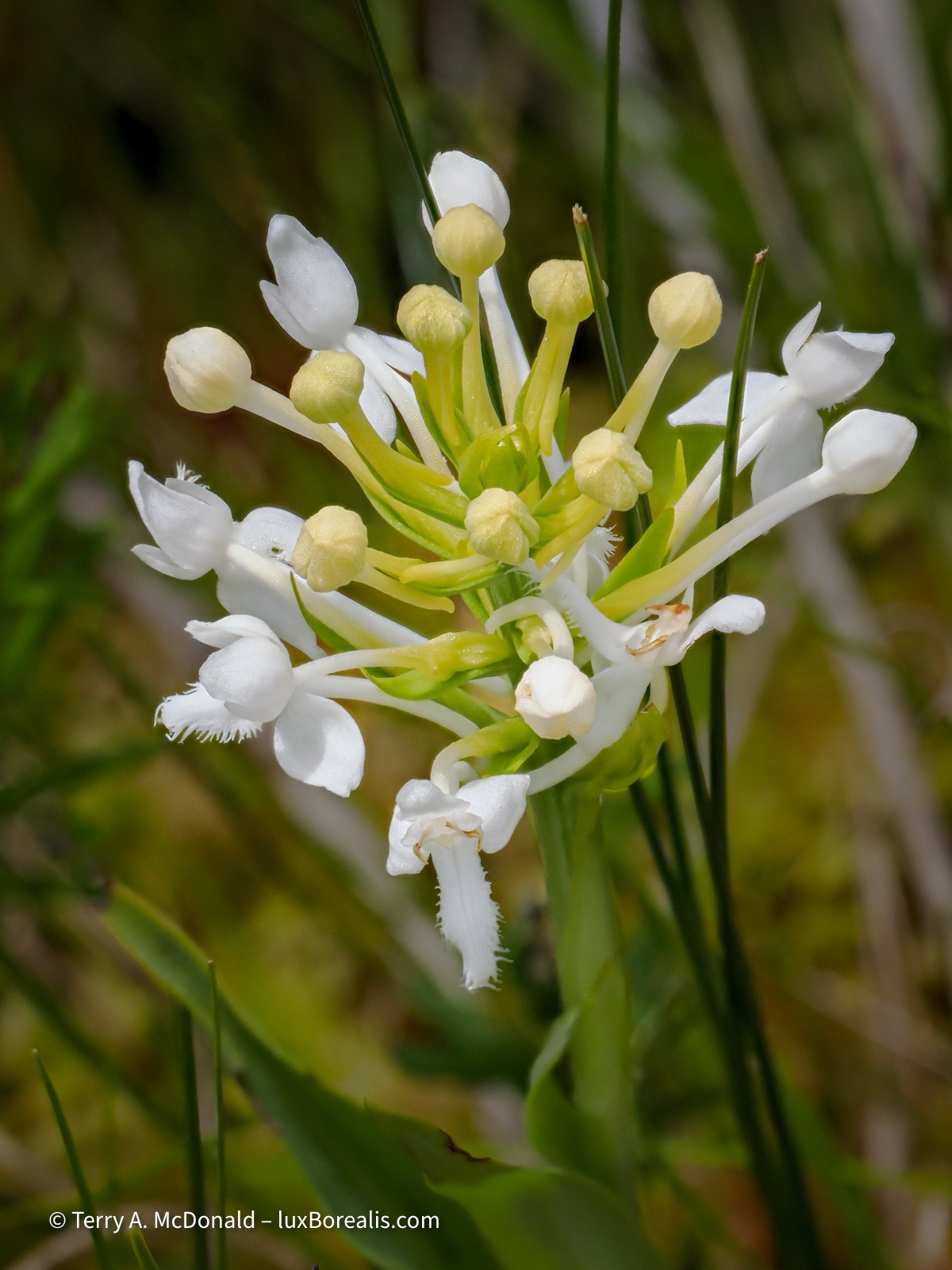
Focus Stack of 10 images
All photos were made with the 100-400mm. While it may seem overkill to use an 800mm equivalent focal length lens for close-ups (why not the 60mm Macro?), working from a boardwalk is restrictive, soi welcomed the extra reach. As well, the close focussing distance of 1.3m at 400mm offers exceptional closeness.
The challenge was the wind. Being at the top of a flat-topped hill over 400m in elevation right next to the sea means all that wind at sea level gets squeezed as it’s forced up and over the hills. So, yes, wind was a challenge. Thank goodness for high ISOs and fast shutter speeds. There was one lull in the wind that allowed me to make a Focus Stack of the White Fringed Orchid. But, the wind can also provide a creative advantage.
OM-1 | 300mm | ƒ13 @ ⅛ | ISO 80 |LiveND16 | Raw | Lightroom
This was not a ‘one-off’ but the result of a number of trial exposures at different shutter speeds and wind speeds.
Flash back
One of the highlights for Laura and I was re-photographing a photograph I made 37 years ago on our honeymoon. The west coast of Cape Breton is particularly dramatic with the Cabot Trail winding its way up and down and around each headland. There are a number of pull offs with panoramic views but one of our favourites is this one near La Bloc Beach. The Cabot Trail is truly one of the most spectacular drives in North America.
OM-1 | 12-100mm/4+POL | ƒ5.6 @ 1/320 | ISO 200 | HHHR | Raw | Lightroom
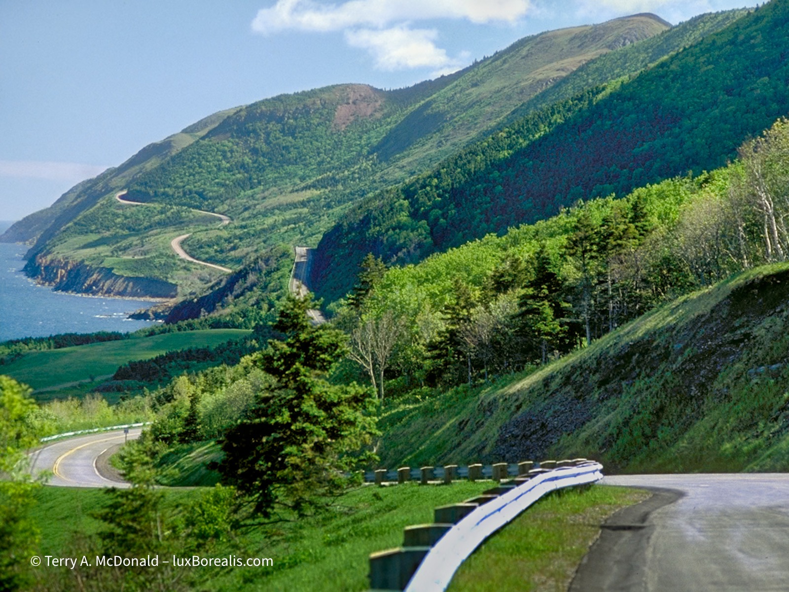
OM-1 | Zuiko 100mm/2.8 +POL| Digital scan from Fujichrome Velvia 50
The trees have sure grown, making the scene appear more natural.
One final photo is a view we passed a few times, commenting each time on how beautiful and pristine this creek and valley look, and hoping a moose might poke its nose out of the bush. Sadly, we didn’t see any moose during our whole trip, but the view is still worth enjoying and one I could stare at forever.
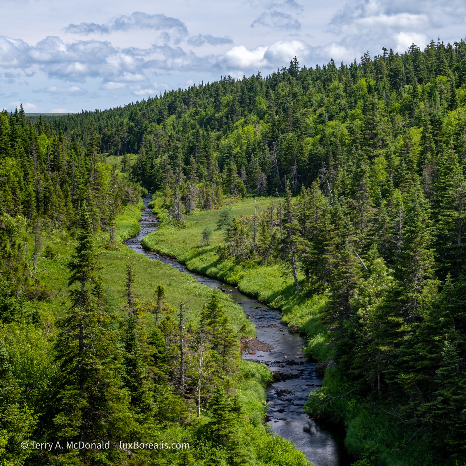
OM-1 | 38mm+POL | ƒ5.6 @ 1/160 | ISO 200 | HHHR | Raw | Lightroom
This brings to an end the Cape Breton portion of my trip Down East. After the family wedding we’ll be attending, I’ll be driving back to southern Ontario will add a post about my stops at Sackville, Hopewell Rocks, and Fundy National Park.
Thanks for reading! Please add to the discussion with a COMMENT, photo or travel questions or observations. Be sure to SHARE with other photographers, travellers, nature-nuts, geo-geeks and with your camera or nature club.
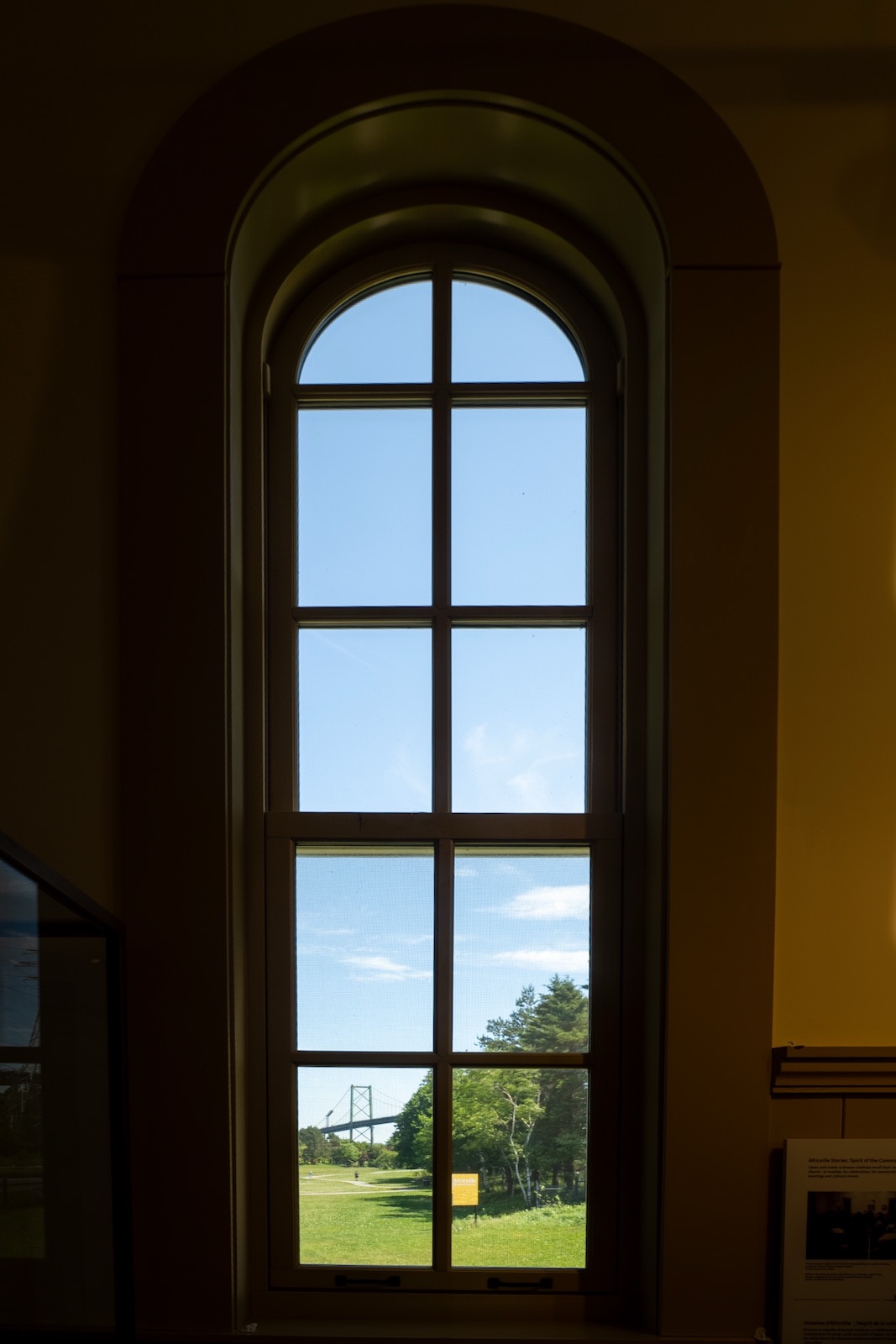
Africville

Tucked beneath the MacKay Bridge to Dartmouth on the Halifax side is a lovely, green city park down by the waters of Bedford Basin. Despite its great location right on the water, it is completely cut off from the rest of the city by industry and railway tracks—accessible only by car or bike, and not by public transit. There is a museum, lots of green space, a ball diamond and children’s play area, but it has no sidewalks, no water, no sewage connections. It is all that remains of a once thriving community.
Where the sidewalk ends, Africville begins.
Imagine being granted land by the Crown for remaining loyal during the Revolutionary War and the War of 1812—just like thousands of other Loyalists: combatants, non-combatants and their families. But, unlike all the other Loyalists, you were never given a deed to your land. And, unlike everyone else in Halifax, you are never provided with water and sewage infrastructure; no electricity, no garbage collection, no street lights, no police, fire or ambulance services—basically nothing. How could this be?
Then, on top of having no services, busy railway tracks were put through the middle of your community right next to the houses. Then, the city decides to put the municipal dump right next to your church. Then a prison. And a slaughterhouse. And an infectious disease hospital. And, the city’s sewage outlet is put into the Bedford Basin right at your community and where you fish for a living, and swim for recreation. Being Baptist, you are baptized by full immersion—in the same water.
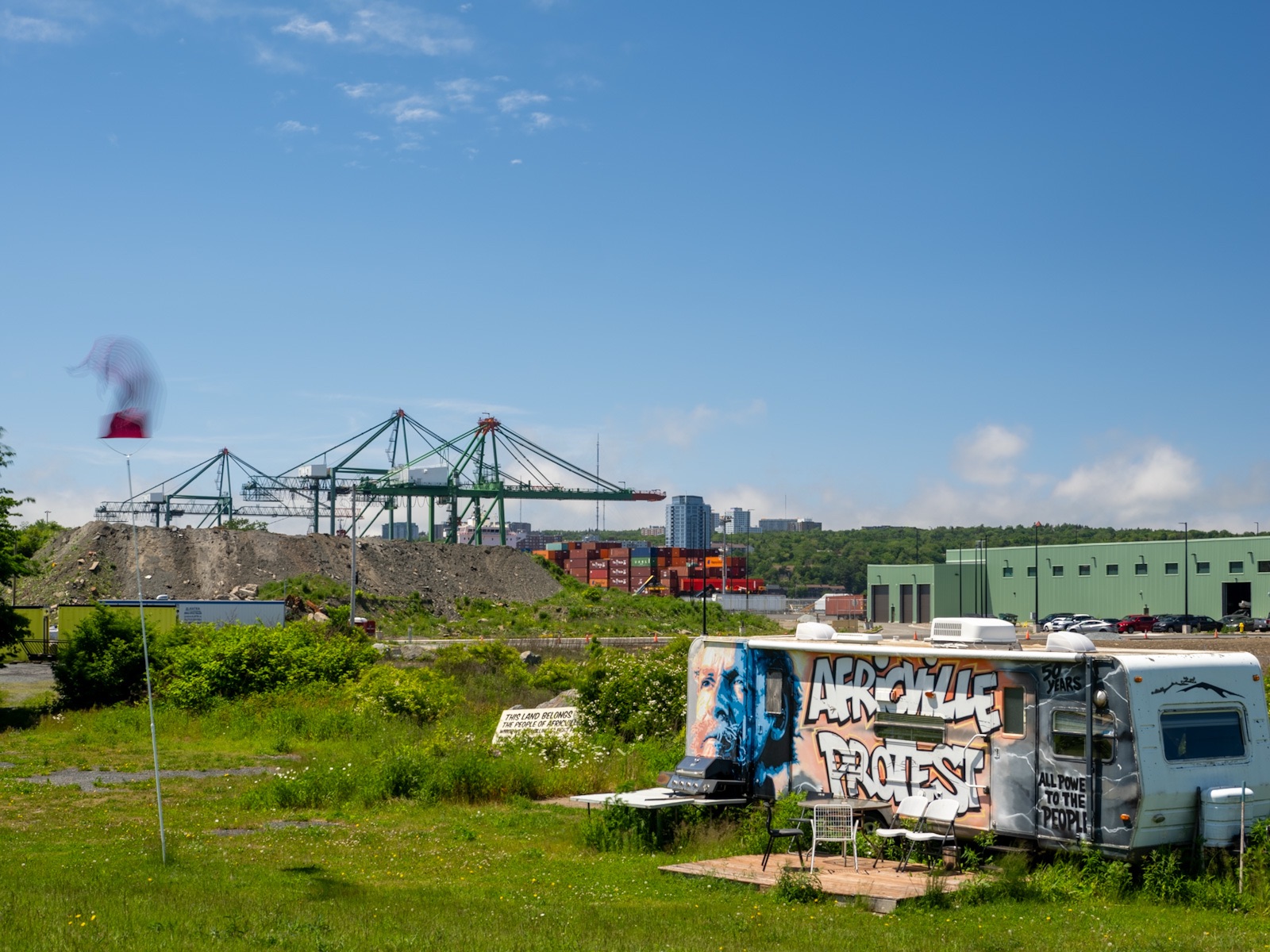
Despite all of this a thriving, loving, vibrant community developed. This was Africville. For over a hundred years, the community not only existed but flourished. The residents may not have had much, but they provided for themselves by themselves, opening small businesses and running small farms. A real community of people developed, people who looked after and looked out for one another.
Then, along comes the city in the 1960s and deems the land ripe for ‘urban renewal’—not for the folks living there, but for industry. The 80 families totalling 400 people were forcibly evicted from their homes, their gardens, their small-holding farms, their businesses, and the centre of their community, their church, all of which was then bulldozed. Then, the city never ended up using the land for the purposes it was confiscated for.
Their land was not ‘expropriated’ as only a few ever received any compensation for their losses. Most were carted off to government housing, their belongings thrown into garbage trucks to be taken with them.
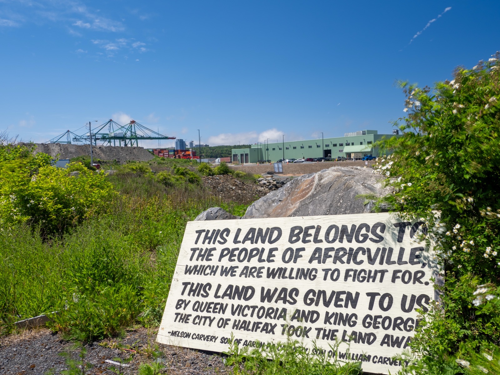
This is Africville. Loyalists, just like every other Loyalist community across Canada, with every right to live out their lives and the lives of their descendants—except for one key difference. Need I tell you that these Loyalists were Black?
After the Revolutionary War, formerly enslaved people from across the new USA who were loyal to the Crown, swarmed to the dockyards of New York to be added to the Book of Negroes, then transported to the British colonies, now known as Canada, with the promise of land and government assistance to get started farming. Needless to say, for this group of Black Loyalists, and a great many others, the promises were hollow. They were left wayward until the land at what came to be known as Africville was provided to them—but not until 1849, decades after the War of 1812 and almost 75 years after the Revolutionary War.
Injustice anywhere is a threat to justice everywhere.
— Dr. Martin Luther King, Jr.
As a descendent of immigrants, this story is significant to me but I found it impossible to capture this injustice as a photograph or photographs, especially with such a bright blue-sky day. While Canadians like to celebrate the role of Upper and Lower Canada as termini to the Underground Railroad, it is just as important to recognize the series of injustices that were occurring at the same time and afterwards.
Pier 21
It was a very different story for our ancestors. The day before visiting Africville, we visited the Canadian Museum of Immigration at Pier 21 on the Halifax waterfront, where over 1 million immigrants arrived to Canada between 1928 and 1971. They were white immigrants as that was Canada’s official policy up until the late 1960s.
Though my Grandfather, at age 3, and Laura’s Grandmother, at age 6, arrived to Québec 20 years prior to Pier 21 opening, visiting the Pier and seeing the exhibits was an emotional reminder of how many Canadians arrived and began their new lives here.
Not so for the Black Loyalists of Africville and their descendants.
For many of us—Scottish, English, Irish, Dutch, German, Czech, Polish, Italian, Greek, and other white Europeans—it is a shared history, a shared heritage. As Canadians of European heritage, we might come to believe Canada is somehow immune from the racism exhibited south of the border.
Not so. Just ask a person of colour.
Friends of ours have too many stories to tell of both subtle and blatant racism by individuals, and the systemic racism that still pervades Canadian society. You may be thinking ‘What racism?” Exactly. As whites, we have the privilege of being blissfully ignorant of it, unless we know people of colour.
Our history classes in school only ever spoke in broad positive ways of the opening of Canada, the great railroad connecting the continent coast to coast, the ‘opening of the west’, the farming prosperity of the Prairies, and the endless forests for timber. It was never phrased as a ‘conquest’. No, that was for the Spanish down in Mexico or the Americans who shot bison from railway cars by the thousands.
Yet, it was, clearly, a conquest—of the original inhabitants of this land. The Canadian government set out a programme of forced assimilation through starvation, using children in experimentation, and the loathful system of residential schools, which have left thousands of indigenous people in Canada with generational trauma. Those decisions, those attempts at forced and legislated elimination of indigenous cultures are now considered a form of genocide.
If you’re feeling uncomfortable with this, well, that’s a good thing.
Being offended is part of learning how to think.
—Robert Fulford
As immigrants, we might well feel offended to think that the Canada we knew and were taught about, one which we have built our history around, is not really the Canada that was. Even at the time, people spoke out in protest and in opposition to the decisions taken by the government, but their protests fell on deaf ears.
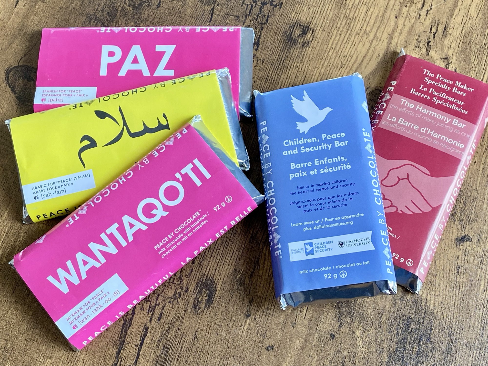
Peace by Chocolate: One peace won’t hurt.
So, stopping in Antigonish today, on our way to Ingonish in the Cape Breton Highlands, was important for the three of us (we picked up our daughter, Allison, two days ago from her flight to Halifax).
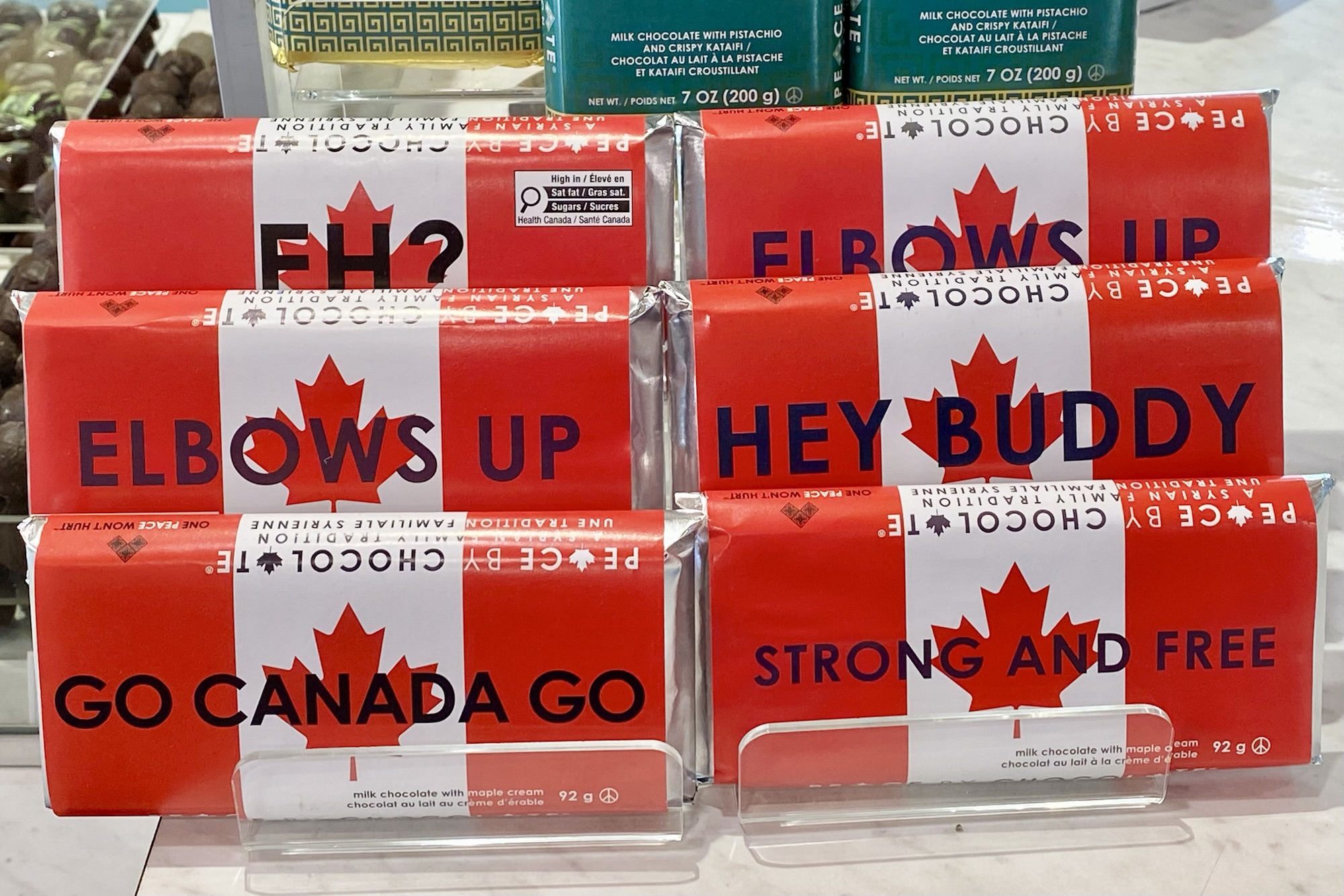
Antigonish is the home of the Hadhad family. They immigrated to Canada in 2015, fleeing the civil war in Syria. Their chocolate factory in Damascus had been destroyed, so they were starting over again, with very little. Perhaps you’ve seen the movie or read about their Peace by Chocolate success story.

For us, it was the realization of finally visiting the ‘home’ of their success story, their shop in downtown Antigonish. The best I could do was to take a few snapshots to convey their core value of promoting peace, multiculturalism and inclusiveness through the sale of their chocolate and philanthropy through their non-for-profit organization Peace on Earth Society.
Other than Indigenous peoples in Canada, we are all immigrants. As immigrants, being aware of our collective failures as well as the successes of Canada’s immigration story is an important part of being Canadian. To paraphrase Spanish philosopher George Santayana, if we don’t understand our history, we are doomed to repeat it.
Thanks for reading! Be sure to add to the discussion with a question, comment or observation in the COMMENTS section. Here’s a photo of Cape Breton to whet your appetite for the next post.

OM-1 | 20mm | ƒ5.6 @ 1/200, ISO 200, POL, HHHR | Lightroom
PhotoGeo Trip Down East: Part 4, Mahone Bay, Nova Scotia
and Lunenburg, Peggy’s Cove, and Blue Rocks . . .
It feels great to be back in Nova Scotia. The whole of Canada’s East Coast has a similar effect of slowing things down compared to the ‘gotta-be-busy-all-the-time’ frenetic pace of southern Ontario. The authentic, chill vibe found down East is much appreciated. In many ways, the following photo captures that mood—‘tranquila’ as our Latino friends say.

OM-1 w/ M.Zuiko 12-100mm at 31mm (62mm efov); ƒ5.6 @ 1/1600, ISO 800, HHHR; raw file processed in Lightroom.
It’s places like this that make the East Coast so photogenic. Quiet bays and traditional architecture are post-cards for the making. Perhaps it makes photography too easy as there is little to jar the senses. The only challenge is the weather, yet ‘good’ weather for photography can be defined in many different ways, as even fog or a stormy day have great potential.
After a couple of days here in Mahone Bay, Dan has now flown home, back to southern Ontario from Halifax. We had an excellent time devoted to serious photography and discovering parts of Canada neither one of us had visited previously. My wife Laura took the return flight back to Halifax to join me for more adventures here in the Mahone Bay—Lunenburg—Peggy’s Cover region, then we’ll be off to Cape Breton Highlands National Park after we pick up daughter who flies in later this week.


OM-1 w/ 12-100mm at 15mm (30mm efov); ƒ8 @ 1/125, ISO 800, HHHR; raw file processed in Lightroom.
In the very harsh light of a bright sky and deeply shadowed lupins, I specifically used HHHR due to its excellent dynamic range. In post-processing, I could raise the shadows without introducing noise. The original raw file is shown above.
Lupins, rhododendrons, azaleas—they are all at their peak in June, with a few lilacs holding onto their blooms as well.
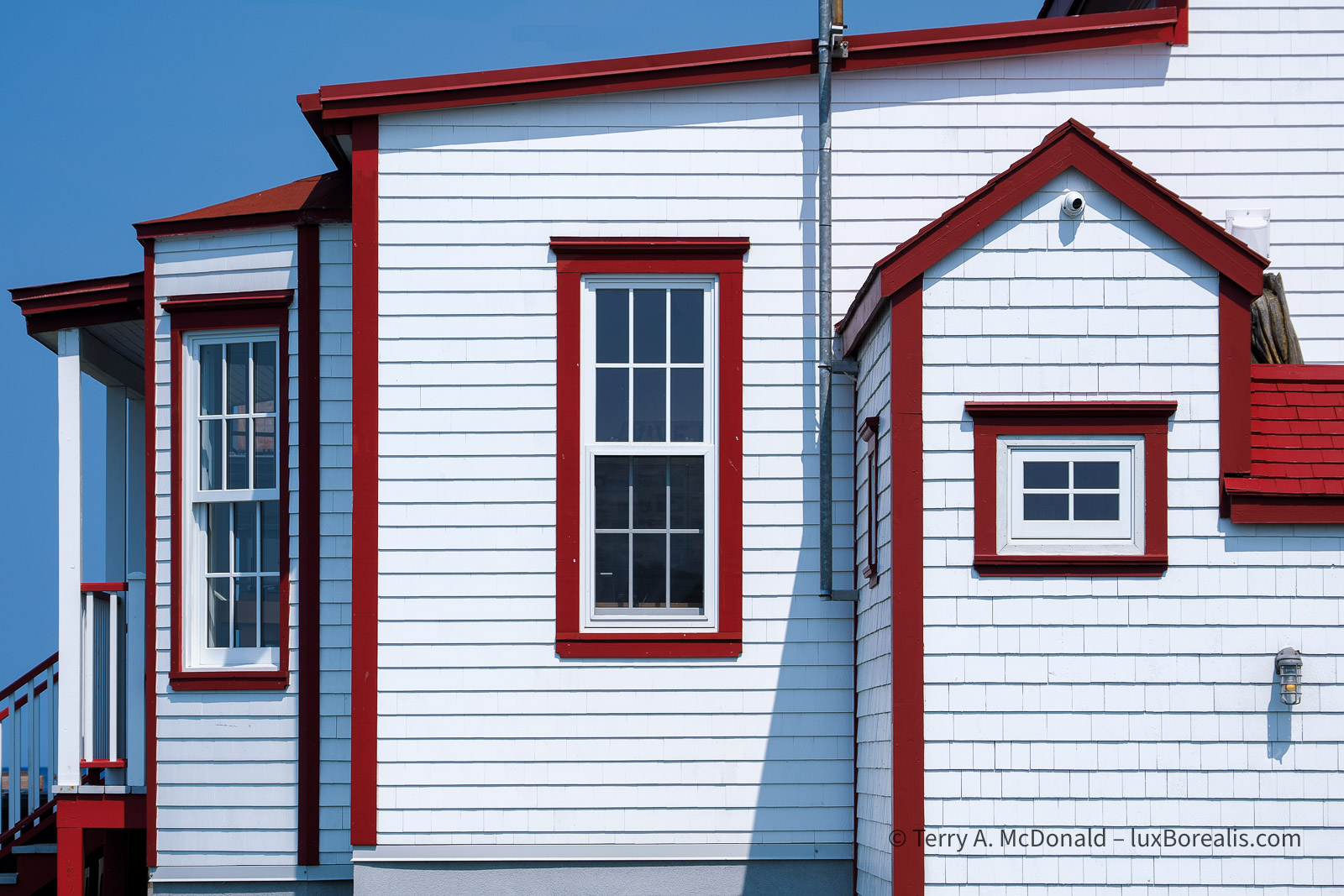
I’m a sucker for angular design elements, so with the simple lines of East coast architecture, colourful houses and contrasting trim, I see photos everywhere. As with all travel photography, I shoot the obvious while keeping an eye out for the details. With an eye to careful composition—using back and side lighting plus eliminating distractions from the frame, such as power lines and stray grasses and branches—striking pictures abound. Note: To view enlarged versions, be sure to click/tap each photo.
OM-1 | 24mm | ƒ5.6 @ 1/200, ISO 800, HHHR | Lr
OM-1 | 25mm | ƒ 5.6 @ 1/160, ISO 200 | Lr

OM-1 | 28mm | ƒ5.6 @ 1/400, ISO 800, HHHR | Lr
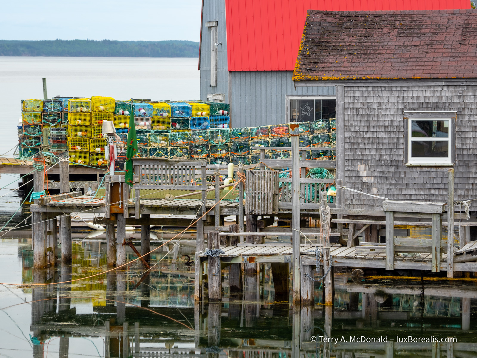
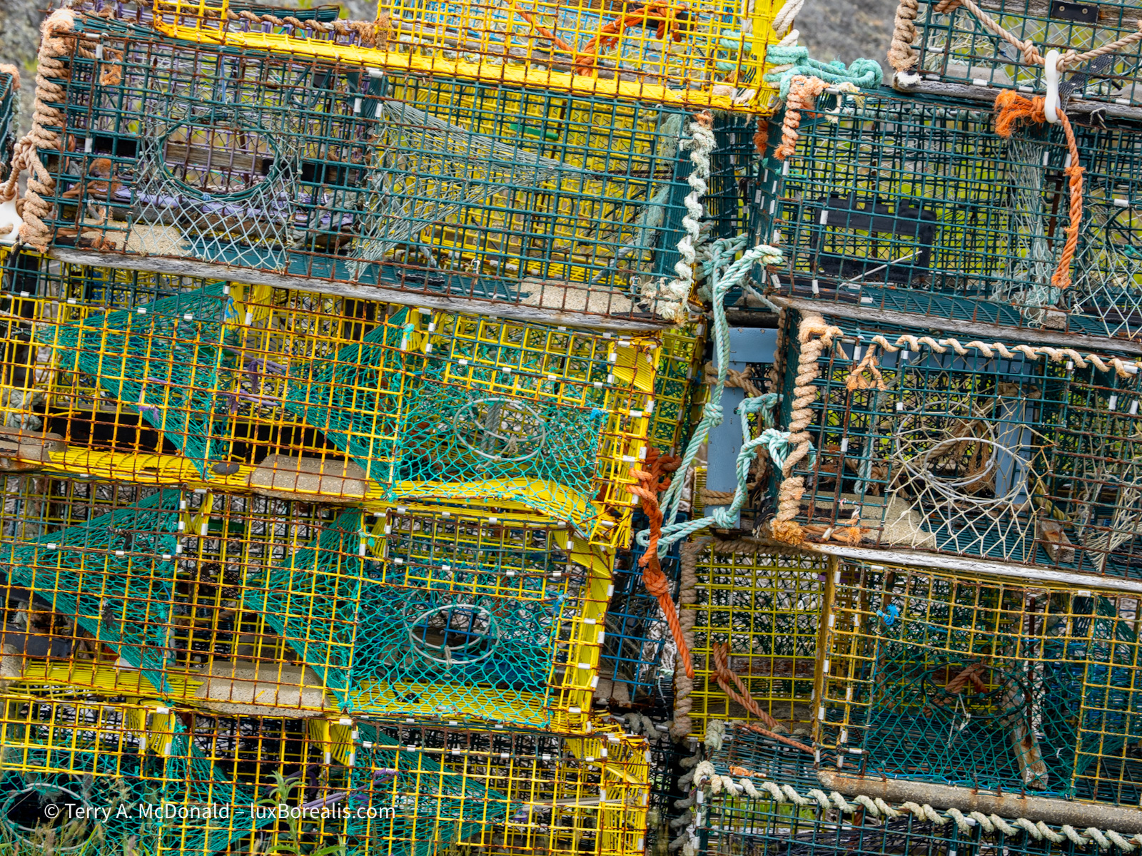
Blue Rocks
South of Lunenburg and Mahone Bay is the small village of Blue Rocks. It’s still a fishing community, to some extent, though many of the houses are now summer homes. The classic views of boathouses and lobster traps are easy enough to photograph, to capture the essence of place . . .
OM-1 | 86mm | ƒ5.6 @ 1/100, ISO 200, TripodHR | Lr

OM-1 | 44mm | ƒ8 @ 1/400, ISO 800 | Lr
OM-1 | 12mm | ƒ8 @ 1/200, ISO 100 | Lr
OM-1 | 92mm | ƒ8 @ 1/20, ISO 100, TripodHR | Lr

OM-1 | 34mm |ƒ4 @ 1/500, ISO 100 | Lr

OM-1 | 12mm | ƒ8 @ 1/250, ISO 800 | Lr
. . . but it took longer and some wandering around, to eventually begin to seeing past the obvious to capture the next level of images. Those who don’t photograph or don’t appreciate more serious photography are often perplexed by how long it can take to go through this process of seeing, especially with ticker tourists who only want a snapshot of the obvious. It’s one of the reasons I appreciated photographing with Dan for those ten days. He ‘gets’ it. My wife Laura also gets it and is very patient, often spending the time capturing her own photographs from her perspective.

OM-1 | 66mm | ƒ8 @ 1/125, ISO 800, TripodHR | Lr

OM-1 328mm | ƒ8 @ 1/400, ISO 800, TripodHR | Lr
OM-1 | 138mm | ƒ8 @ 1/160, ISO 800, TripodHR | Lr
OM-1 | 75mm | ƒ16 @ 5sec., ISO 100, LiveND64 | Lr

OM-1 | 100mm | ƒ16 @ 10sec., ISO 100, LiveND64 | Lr

OM-1 | 86mm | ƒ8 @ 2sec., ISO 100, LiveND64 | Lr
In making these photographs, I got back to my roots and used a tripod while putting the OM-1 through its computational paces. TripodHR was the obvious choice, but having a sturdy platform also opened up more possibilities for using LiveND64 to capture the movement of the bright yellow rockweed. Using ISO 100 slowed the shutter speed down even further, without having to resort to a smaller aperture.
After using LiveND extensively on this trip, I’m thinking I may go back to using glass ND filters when it is bright out. With the brightness comes smaller apertures to get slow enough shutter speeds to show movement, even at ND64. With smaller apertures—ƒf11 and ƒ16–I’ve notice a decline in sharpness. The other advantage to glass ND filters is I can shoot using TripodHR which is not possible when using LiveND.
Lunenburg
There are two ‘cruise line’ destinations in this part of the East Coast: Lunenburg and Peggy’s Cove. Lunenburg is a UNESCO World Heritage Site, having kept its ‘planned British colonial settlement’ look. Dan and I were there on Saturday and it was a bust due to all the tourists. On Monday, with Laura, it was much less busy, but still had a ‘tourist trap’ vibe. Even with the Bluenose II in port, there was only a smattering of people around it. I’m sure I could have made dozens of beautiful photos throughout the town of the gorgeous houses and details, many of which are in tip-top condition, but I was on the look out for something different.

OM-1 | 100mm | ƒ8 @ 1/160, ISO 200, HHHR | Lr

OM-1 | 34mm | f?8 @ 1/00, ISO 200, HHHR ? Lr

OM-1 | 57mm | ƒ8 @ 1/250, ISO 200 | Lr and Pages
It was a fun challenge that resulted in a grand total of three photographs. Golden Dories is thanks to the Canadian Dory Racing Association and some fun with composite imagery, along with a nod to Stompin’ Tom Connors’ whimsical song, The Man in the Moon is a Newfie, who’s “sailin’ on to glory, away in the golden dory”.
Peggy’s Cove
Like Lunenburg, Peggy’s Cove is a huge tourist draw. After arriving, we turned around and left. There were simply too many people all after the same view. Decades ago, Laura had visited Peggy’s Cove; I’d never been, but I’ll be back, perhaps in the winter or at 6am when the place isn’t crawling with people. By nature, we’re not ‘tickers’, so I don’t at all feel hard done by. I’d rather put my energy into finding landscapes that are more unique.
Instead, we spent some time at the beautiful Swiss Air Flight 111 Memorial nearby. Then, we found a little cove just down the road, deserted of tourists, but with photographic potential and views few others will see.

OM-1 | 23mm | ƒ11 @ 1/40, ISO 200 | Lr

OM-1 | 29mm | ƒ8 @ 1/160, ISO 800, HHHR | Lr
Some of the other views that caught my eye are:
OM-1 | 24mm | ƒ8 @ 1/250, ISO 800, HHHR | Lr

OM-1 | 12mm | ƒ10 @ 1sec., ISO 100, HHHR | Lr
OM-1 | 47mm | ƒ5.6 @ 1/2000, ISO 800. HHHR | Lr

OM-1 | 15mm | ƒ8 @ 1/250, ISO 400 | Lr
OM-1 | 57mm | ƒ5.6 @ 1/25, ISO 200, HHHR | Lr
I hope these photographs adequately portray the atmosphere of the South Shore of Nova Scotia and the peacefulness I felt when making them.
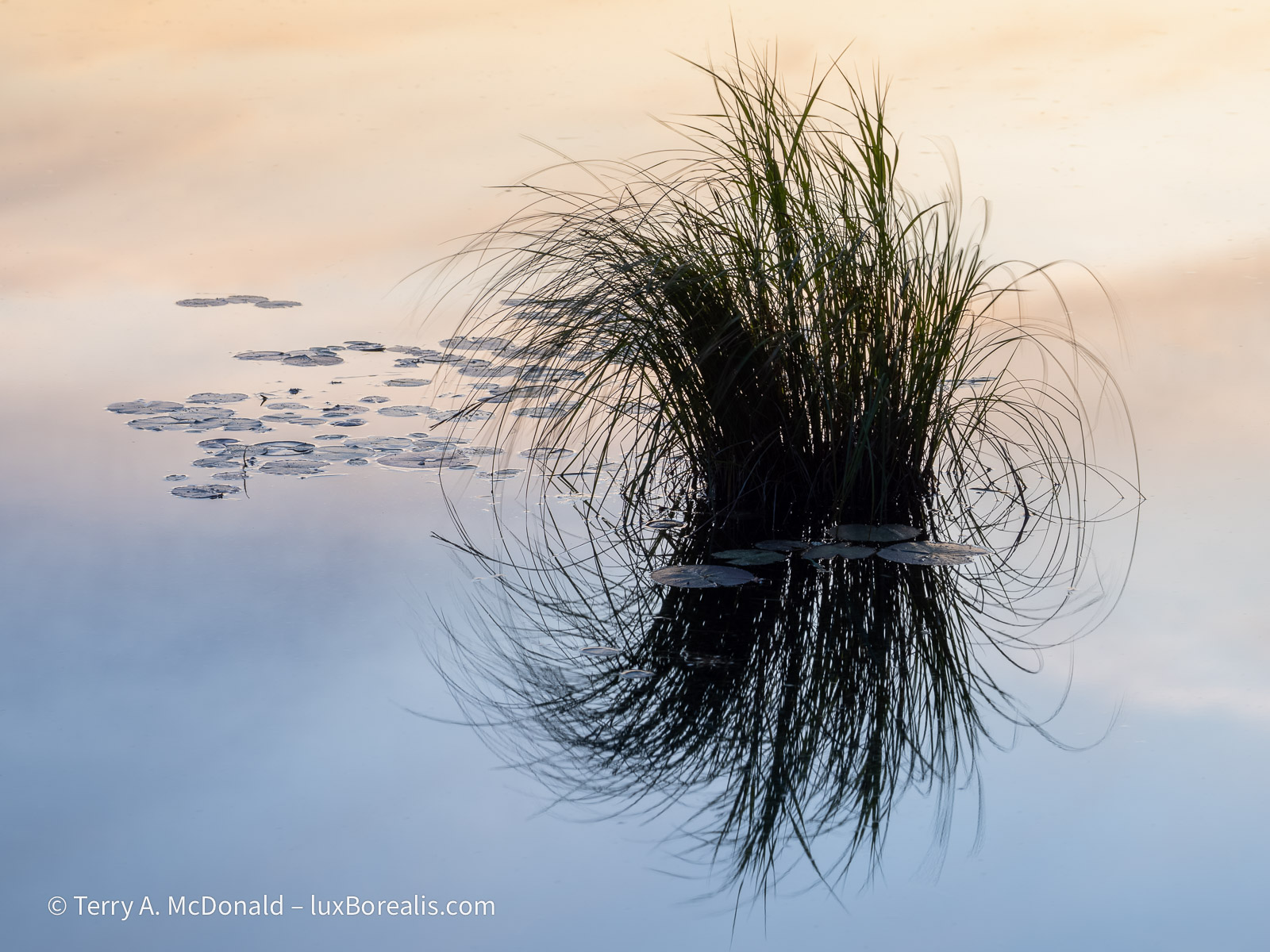
The last photo, Grasses, is from a particularly fascinating place. Near where our BnB was at Indian Point, is a massive 2m by 20m beautifully arced beaver dam. The grasses are from the pond behind the dam. But the interesting thing is that the Fire Department has constructed a gravel drive below the dam and an access ”deck” to the dam as an alternate source of water. Huh? That’s right—they are using the ingenuity and ’free labour’ of the beavers to ensure they have an adequate back-up water supply.
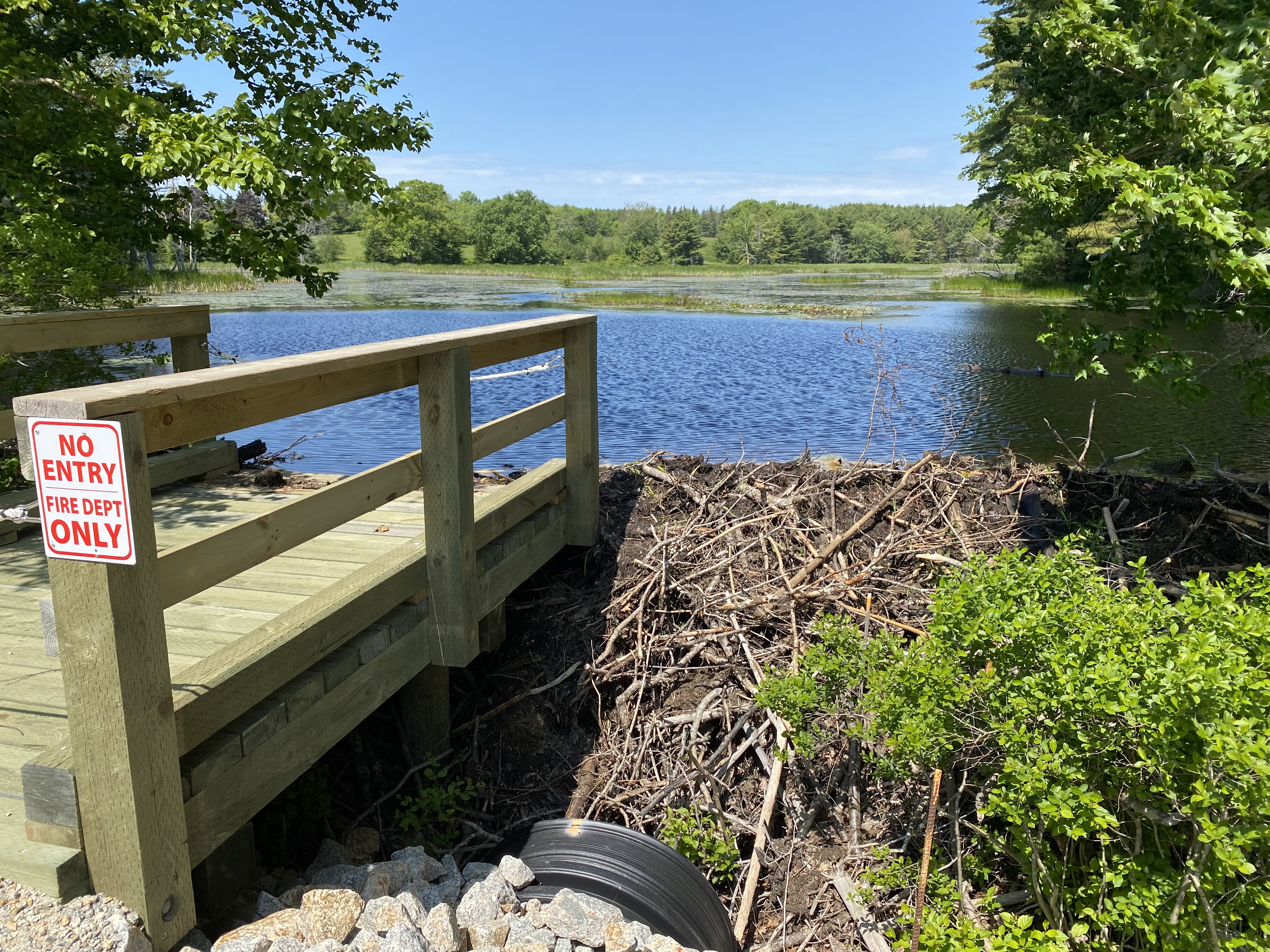
Wonders never cease. Maybe it’s a Down East thing, working with nature, not against it, like we seem to do all too often.
Thanks for reading! I’ll have more photos from Halifax and the Cape Breton Highlands over the next week. Please add to the discussion with your questions, comments and observations in the COMMENT section and be sure to SHARE and SUBSCRIBE!
PhotoGeo Trip Down East: Part 3
In the previous installments, I described our trip through the Eastern Townships and the Charlevoix Region of Québec, followed by Saguenay Fjord, then Forillon National Park out on the Gaspé Peninsula. Now we’re headed into the Maritimes proper: New Brunswick and Nova Scotia.
Kouchibouguac National Park
(That’s ‘Koo-shi-boo-zhou-ack’ for the uninitiated.)
If we thought the drive to Forillon was long, from Forillon to Kouchibouguac seemed to take forever, especially through Québec. Every time we would get up to the speed limit of 90km/h, there would be yet another dump truck and another ‘Travaux’ sign (construction) or a small town with stop lights, where the speed limit would drop to 70, then 50 and even 30 if a school was along the route. I could never quite get into a rhythm of driving. Ugh!
That changed when we crossed into New Brunswick as NB has a limited access highway. It’s only one lane in each direction (with passing lanes on hills), but a constant 100km/h made all the difference. Of course, the long day became even longer when we factored in the time change to Atlantic Time, but it was still bright and sunny when we arrived at Kouch.
Where Forillon is dramatic, with its cliffs and ridges, Kouch is sublime. Mostly forested, with no topography, it’s just a gentle slope down towards the salt marshes and barrier islands of the coast. However, it was a great place for birding and bird photography.
OM-1 w/ M.Zuiko 12-100mm/4 PRO at 16mm (32mm efov); ƒ5.6 @ 1/1000, ISO 200; raw file processed in Lightroom.
The rather significant boardwalk out to one of the barrier beaches was a great starting point. Though the herons don’t arrive from their nests (in a heronry far, far away) for another month, Common Terms were feeding. Their acrobatics proved a good challenge for practicing bird-in-flight photography. I have my C3 set with bird tracking, C-AF Silent, spot focus and spot exposure, and ISO 1600. I’ll switch it up to 3200 if needed or down to 800 when possible. Timing the terns’ entry and getting just the right angle to show the subsequent catch took some effort, and a lot of missed frames! There was also a willet out and about, and a double-crested cormorant.

OM-1 w/ 100-400mm at 400mm (800mm efov); ƒ8 @ 1/3200, ISO 3200; raw file processed in Lightroom and Topaz PhotoAI.

OM-1 w/ 100-400mm at 400mm (800mm efov); ƒ8 @ 1/3200, ISO 3200; raw file processed in Lightroom and Topaz PhotoAI.

OM-1 w/ 100-400mm at 400mm (800mm efov); ƒ8 at 1/6400, ISO 3200; raw file processed in Lightroom and Topaz PhotoAI.
Dan kept a running list of bird calls and sightings on his phone using Merlina nd eBird and though the list was long, the photo ops were few and far between. The afternoon was spent out on the Bog Trail under threatening skies and rain, followed by part of the River Trail from La Source..
OM-1 w/ 100-400mm at 400mm; ƒ8 @ 1/2500, ISO 800; raw file processed in Lightroom.
The bog was wonderful, with excellent interpretation. I learned that it is an expanding bog, gradually growing outwards. As the peat piles up forming a dome, the moisture seeping out chokes out the surrounding trees—so different from many bogs in Ontario that are shrinking as the trees grow in from the outside. There were many bog plant species to photograph. We even had a very quick flyover of an immature bald eagle.


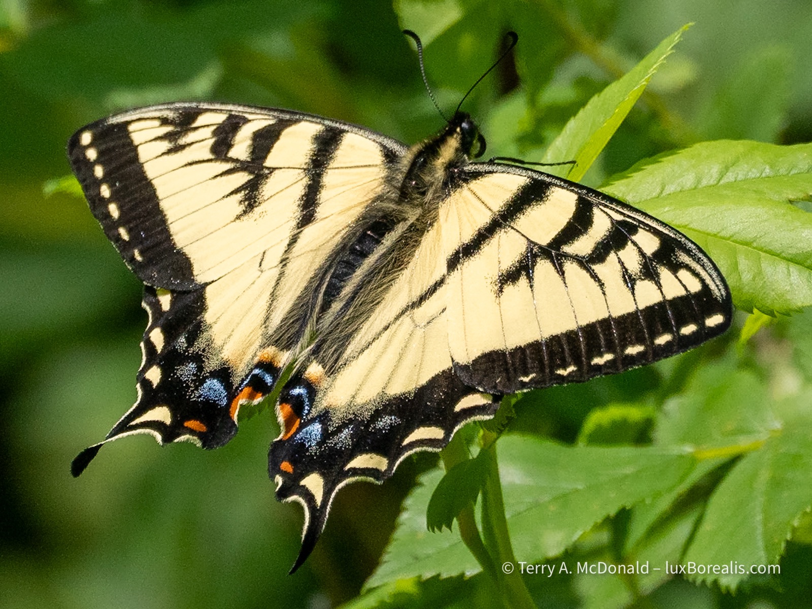
The five photos in the gallery above were made NOT with the M.Zuiko 60mm macro lens as you might expect, but with the ever-versatile 100-400mm zoom., mostly at 400mm, with a couple at 200mm. Unless I am specifically working on macro photos, having the ability to focus very closely, down to 1.3m (at 800mm efov!) means one less lens to carry. It also provides excellent working distance, as was the case with the swallowtail shown above, as well as providing a more blurred background.
———
The trail along the river didn’t yield much, other than the swallowtail and, finally, the most mystical, magical, melodic of singers in the forest—a Swainson’s Thrush. You can listen to it here (YouTube). The one above us literally posed for us, sitting in a forest opening on a the limb of a dead tree.
OM-1 w/ M.Zuiko 100-400mm/5-6.3 at 400mm; ƒ8 @ 1/640, ISO 800. Being in the forest, I started shooting at ISO 3200, but quickly realized there was light enough for a lower ISO. I’ve never been a big fan of Auto ISO as I like to be in control of shutter speed and ISO. Raw file processed in Lightroom and Topaz PhotoAI.
Sackville Waterfowl Park
After a quiet morning and a later start—not too long a drive today—we were on our way to Mahone Bay, south of Halifax. On the recommendation of a woman we met on the River Trail who was a birder, we stopped at Sackville Waterfowl Park, part of the vast Tantramare Marsh. The Internet tells me that “Tantramar is derived from the Acadian French word “tintamarre,” meaning ‘din’ or ‘racket,’ which refers to the noisy flocks of birds that feed in the Tantramar Marshes”. Part of the vast marshlands are protected as a National Wildlife Area as it is critical for migratory birds.


Birds of the sackville Waterfowl Park. Click on photos to view larger versions.
OM-1 w/ 100-400mm at 400mm (800mm efov). Raw files processed in Lightroom and Topaz PhotoAI. For the Swallow, ProCapture2 was used to capture it’s take-ff from the top of a nesting box.
———
The Waterfowl Park is just one small part of it and is a city park with boardwalks all around providing great views of a number of habitats. Across the highway is another part that is next to the regional high school, whose students play a key role in managing that part of the marsh. Needless to say, we were duly impressed—much better than anything we can relate to in southern Ontario, whose ‘nature infrastructure’ for marshes and wetlands seems woefully lacking in comparison, both in terms of natural areas protected and access to them.
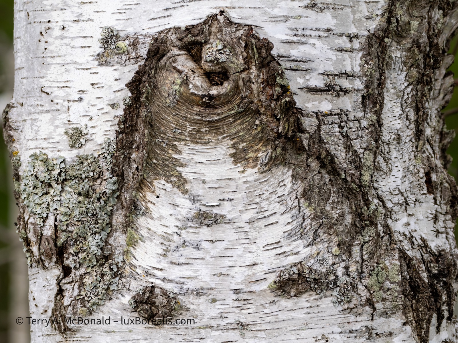

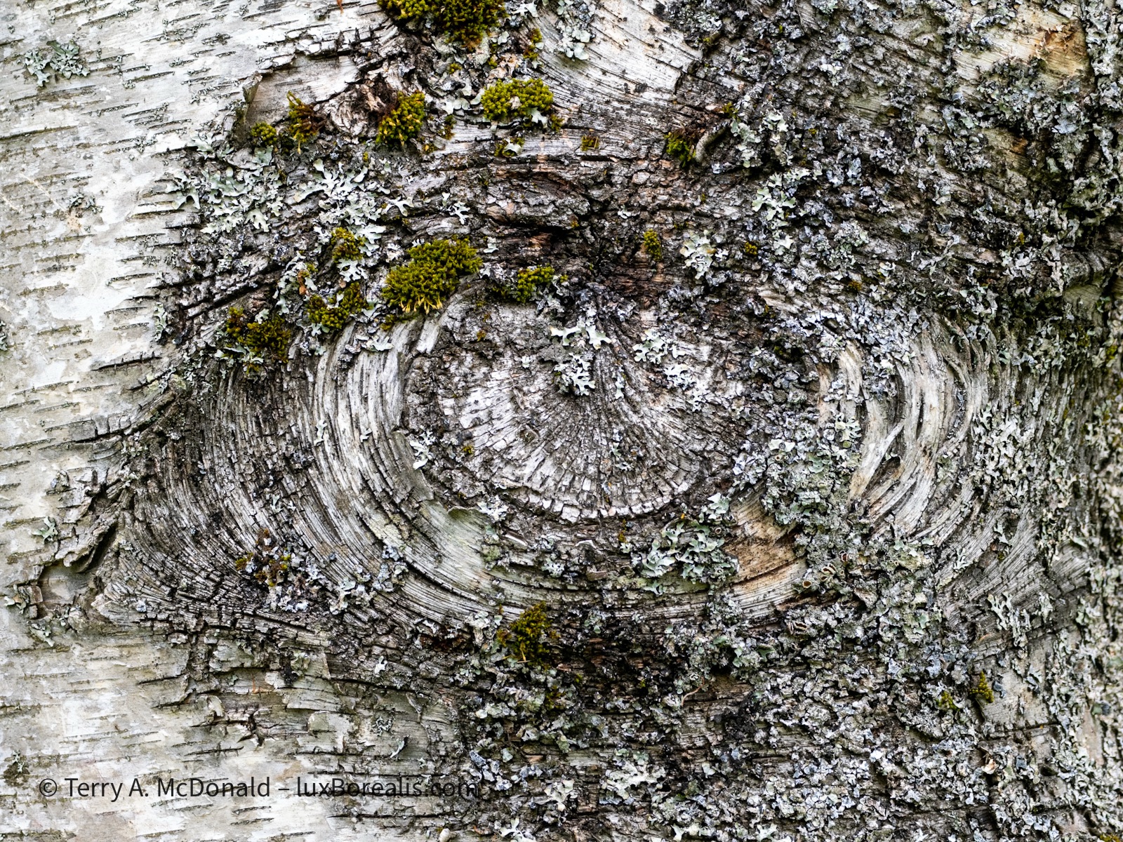

Details: Birches All OM-1 w/ 100-400mm at 200mm (400mm efov). Click on photos to view larger versions.
One of the trails at the Waterfowl Park was called ’The Birches’. While only a couple of these photos are from that trail, it’s hard not to pass up close-up studies of the various designs of bark-splits and lichens on the trunks of birch trees—similar to looking at clouds on a summer day.
———
While we never expected to find one, the woman who recommended Sackville Waterfowl Park said there were nesting Pied-billed Grebes. Sure enough we found not one but two nests. Grebes are such skittish birds, at least they up on the Rideau where I usually see them. But here they were nesting in plain site of anyone walking along the boardwalk. Very convenient for someone with a telephoto lens!


Pied-billed Grebe (Podilymbus podiceps) Both OM-1 w/ 100-400mm at 400mm (800mm efov).
On the left, the grebe is pulling matts of foliage around and over the nest. The decomposing foliage helps keep the eggs warm. The awkward legs and huge webbed feet can be seen in the photo on right. I can’t Imagine this bird ever being able to move on land!
———
What a gem of a park! We ended up spending about three hours there, far longer than expected. Two hours later we were on the seacoast, at our BnB in Mahone Bay, Nova Scotia. What a beautiful spot and very photogenic—Mahone Bay is well-deserving of its own blog post.
Thanks for reading. Be sure to add to the discussion with a question, comment or observation in the COMMENTS section.
PhotoGeo Trip Down East: Part 2
Maybe it’s the Three Day Rule. Or perhaps it’s being in the boreal north, up on the Canadian Shield. Either way, I’ve noticed a marked improvement in the photo ops we been having over the last few days.
The Three Day Rule relates to a person’s need for three days in a new place to establish a new routine and begin feeling comfortable again. It’s a phenomenon that has been noticed in a variety of situations, including NASA space voyages and with regular people like you and me while travelling.
Dan and I are now five days in and, although we’ve moved twice, more of a routine is developing.
Add to that the bliss of being in the boreal north, and all is right with the world.
Parc national du Fjord-du-Saguenay
The honk of the Ravens, the sweetly singing White-throated Sparrow—Oh Sweet Canada, Canada, Canada—the rocky rivers and pristine lakes, the deranged drainage patterns, bunches of bunchberry, and the rugged hills forested with black spruce and balsam fir—to me, these all speak of a peacefulness I can never find in southern Ontario.
Today it was the thrumming of a Ruffed Grouse, echoing through the forest; his attempt to attracting a mate with his rapid wing beats.
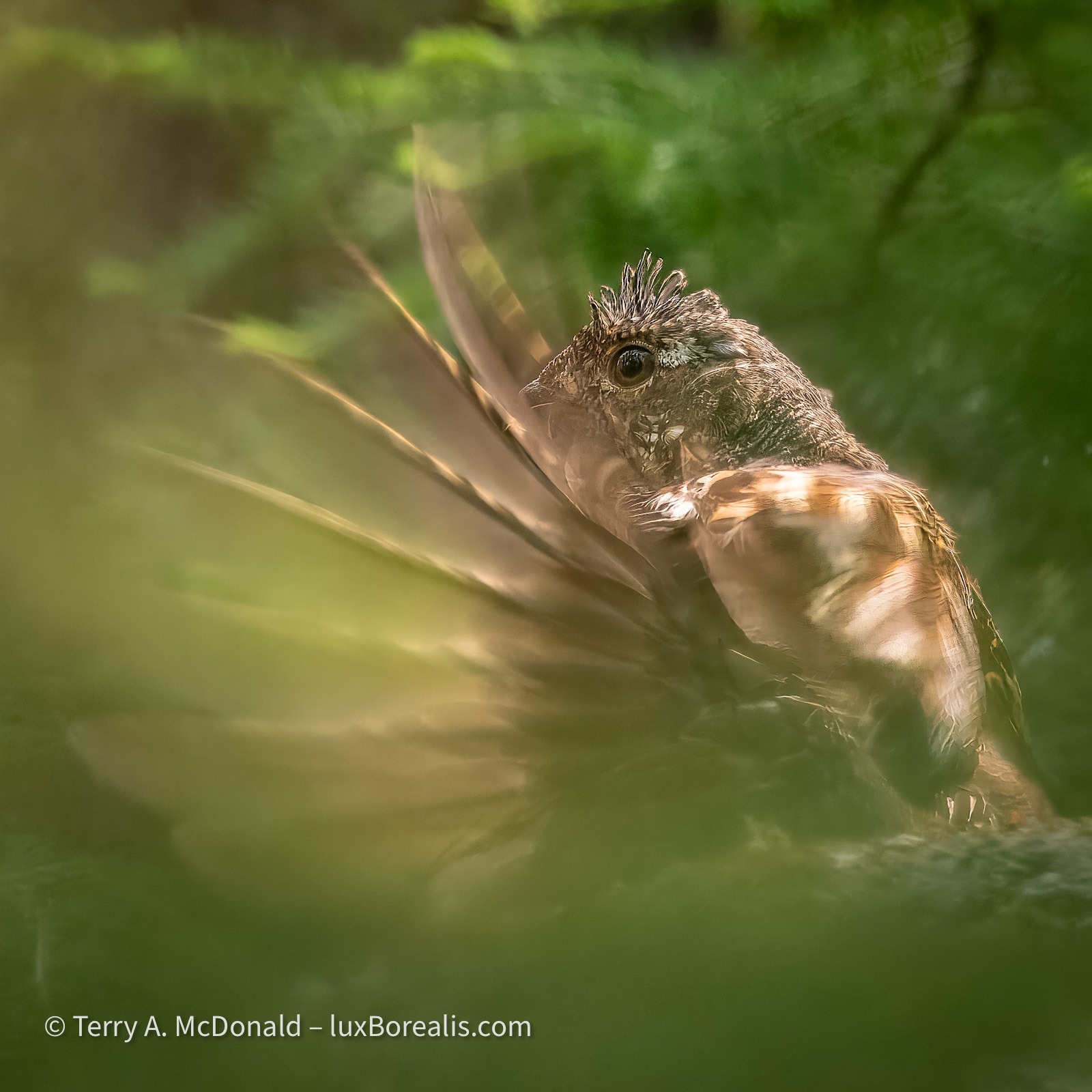
OM-1 w/ M.Zuiko 100-400mm ƒ5-6.3 at 400mm; ƒ8 @ 1/160, ISO 200, POL; raw file processed in Lightroom and Topaz PhotoAI for improved sharpening around the head and better definition in the feathers.
A polarizer filter is an essential tool in nature photography for reducing the glare from foliage and water. However, for a shot like this, I would typically remove it, but in the heat of the action I had forgotten it was on from photographing the cliffs of the fjord.
Nineteen—that’s the cost of this Ruffed Grouse photo. Nineteen black fly bites—and that’s just on my arms! Oh, and that’s with Muskol on, too. I’m glad I changed into long pants.
After the first thrum—so close we could feel it. Dan pointed upwards into the bush. The grouse was on a rocky outcrop about 2 metres above us and about 8 metres into the thick of the forest. The next 30 minutes were spent looking for a window through the branches and needles, carefully moving one foot then the other so as not to alarm him.
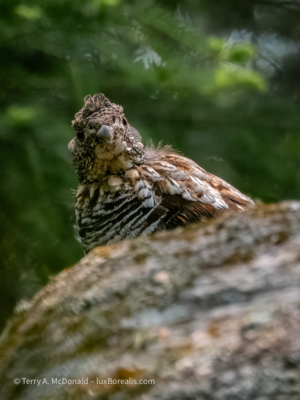
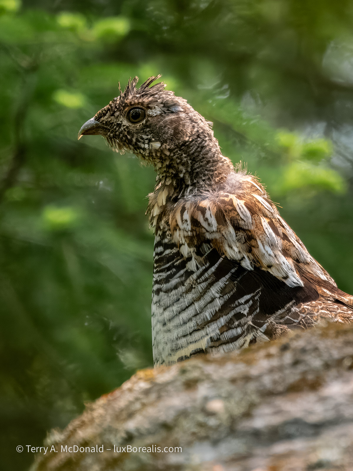
Ruffed Grouse (Bonasa umbellus), Male, Parc national du Fjord-du-Saguenay.
OM-1 w/ 100-400mm at 400mm (800mm efov); ƒ8 @ 1/250, ISO 6400; raw file processed in Lightroom.
Our stealth paid off. Periodically he would drum, starting slowly, thruuuuump, thruuuuump, thruuump—then gradually picking up speed to a a crescendo of wing beats. I could hear David Attenborough in my head describing “the mating ritual of the ruffed grouse”!
I would love to say that catching the movement of the wings was planned, but in reality, it was the limitations of light that gave me what turned out to be the ideal shutter speed to catch the wing movement.
OM-1 w/ 100-400mm at 400mm (800mm efov); ƒ8 @ 1/4000, ISO 800; raw file processed in Lightroom
What was supposed to be a 10-minute trail to three viewpoints over the cliffs of the fjord turned into an hour and a half of birding and photography. The magnolia warbler was incessant in its singing, moving from branch to branch, then to the massive hydro-electric pylon which, in itself is impressive, carrying cables across the 1500m width of the fjord.
OM-1 w/ 100-400mm at 400mm (800mm efov); ƒ8 @ 1/800, ISO 800; raw file processed in Lightroom and Topaz PhotoAI.
Earlier in the morning we walked up and down the gravel road outside our accommodations at L’Anse-Saint-Jean, birding and photographing. The bird song was constant.
Given the shutter speed used to capture this, I am ever thankful for the excellent IBIS in the OM-1. Just a light sharpening in Topaz brought this image back to usefulness.
OM-1 w/100-400mm at 400mm (800mm efov); ƒ8 @ 1/50, ISO 800; raw file processed in Lightroom and Topaz Photo AI.
One of my favourite photos of the trip is this simple one of a fern in the forest, backlit by the morning sun. I used Focus Stacking to achieve full depth of field.
OM-1 w/ 100-400 at 400mm (800mm efov); ƒ8 @ 1/500, ISO 3200; Focus Stack of 8 images; raw file processed in Lightroom.
The only editing done on this was to increase the ‘Whites’ by 50 to better accentuate the rim lighting on each leaflet.
At 105km, the Saguenay Fjord is the 5th longest in the world and one of very few that empties into an estuary and not directly into the ocean—and it is staggeringly beautiful. While not as narrow and picturesque as many Norwegian and Greenlandic fjords, its cliffs plunge some 200 to 300m in sheer drops to the water. Given clear weather and not the milky skies we had, I would be publishing more than just these two.
OM-1 w/12-100mm at 17mm (34mm efov); ƒ14 @ 2sec., ISO 200; LiveND64; raw file processed in Lightroom.
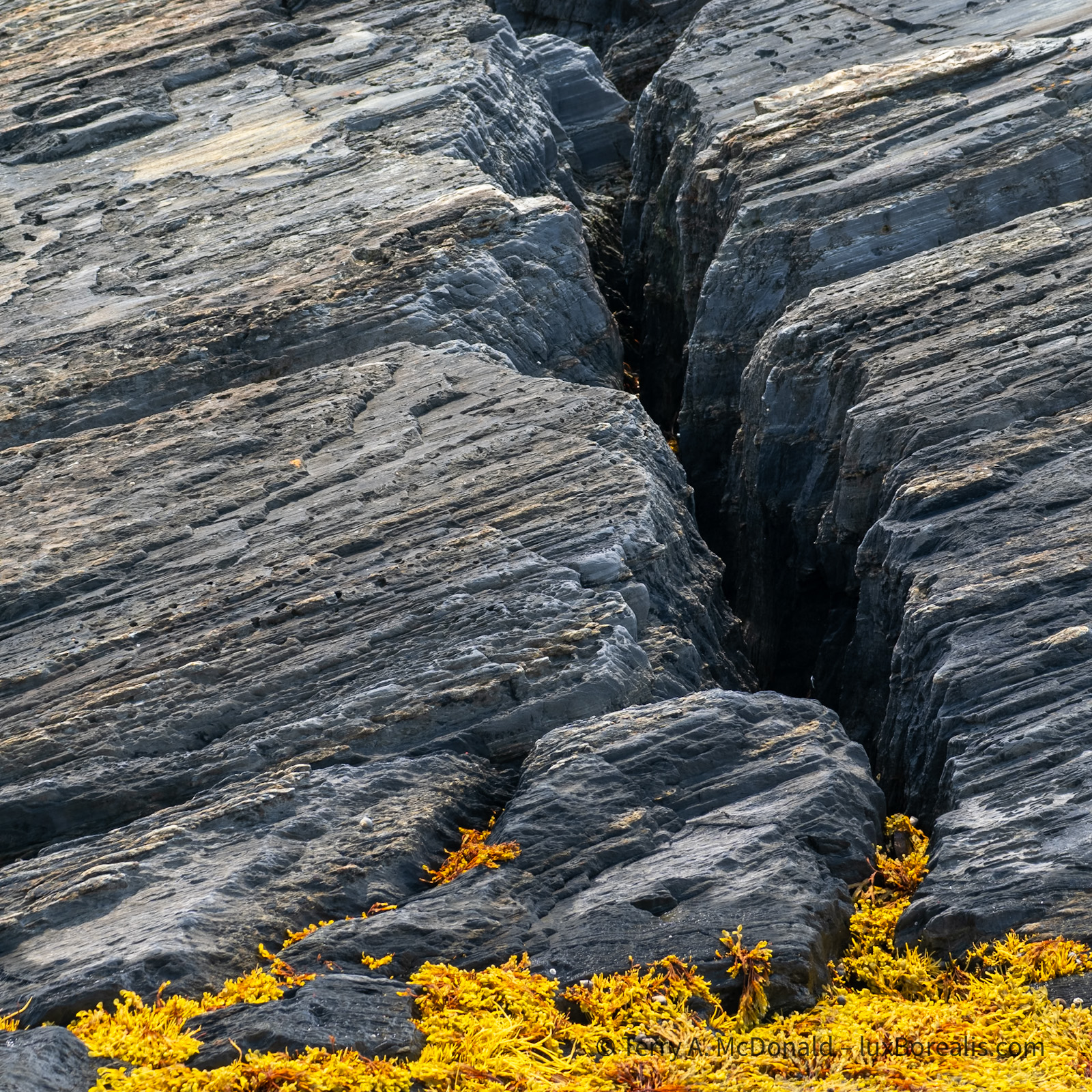
OM-1 w/ 12-100mm at 12mm (24mm efov); ƒ8 @ 1/100, ISO 200, POL; raw file processed in Lightroom. Foreground is always important in landscapes. Having survived millennia of erosiona nd repeated glaciation, this ancient, tortured, fractured rock was ideal.
However, there are some stunningly beautiful, rocky rivers running through the park and on the way to and from the Saguenay that are definitely worth a stop.
This first one, came out of nowhere. As Dan and I zipped along the highway, we caught a glimpse of what appeared to be a dilapidated bridge—stopped and went back. In fact, it’s a ski-doo trail bridge, where we spent 30 to 45 minutes, pondering and photographing, crossing the bridge and back again, looking for just the right perspective. At first, I was baffled about how to capture this unique statement of the winter culture, but gradually I began to see this image.
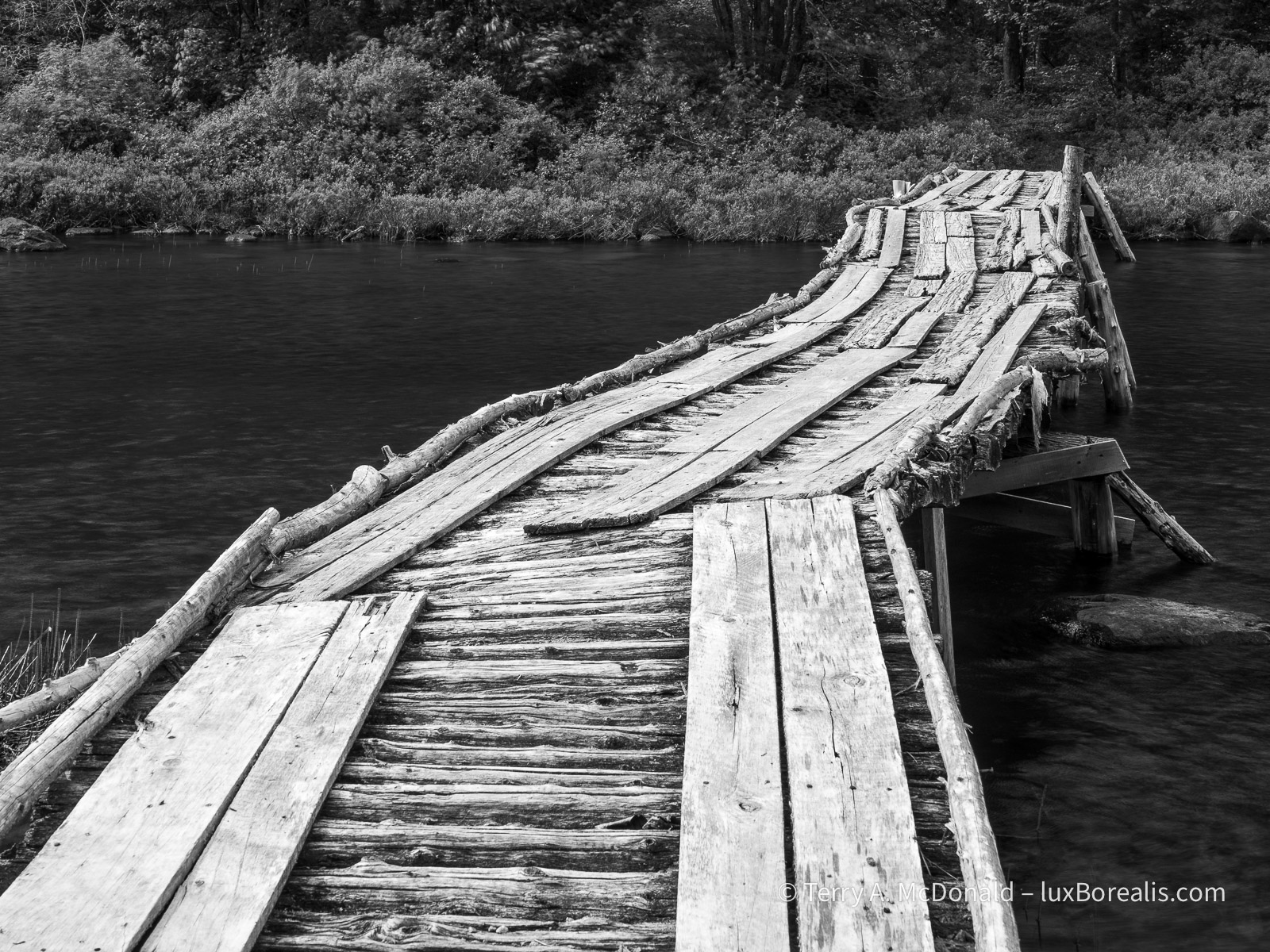
OM-1 w/ 12-100mm at 28mm (56mm efov); ƒ8 @ 1/320, ISO 800, POL, HHHR; raw file processed in Lightroom.
I photographed this scene in two ways: (1) using HHHR to slightly blur the river; and (2) using the normal 20MP setting which froze the river. I prefer the softer blurring of the river, which is the photograph presented here.
I’ll often do that—shoot both normal and HHHR. I’m finding the HHHR advantages of blurring moving water and added dynamic range to be very helpful. The blurring of the water has to be checked carefully: if the shutter speed is too high relative to the flow of water, then the flow can appear staggered or cut up, rather than smooth.
This second river photo was done along the highway between Saint-Simeon and the Saguenay. There were a number of stops we could have made, but, as was often the case, time was getting on.
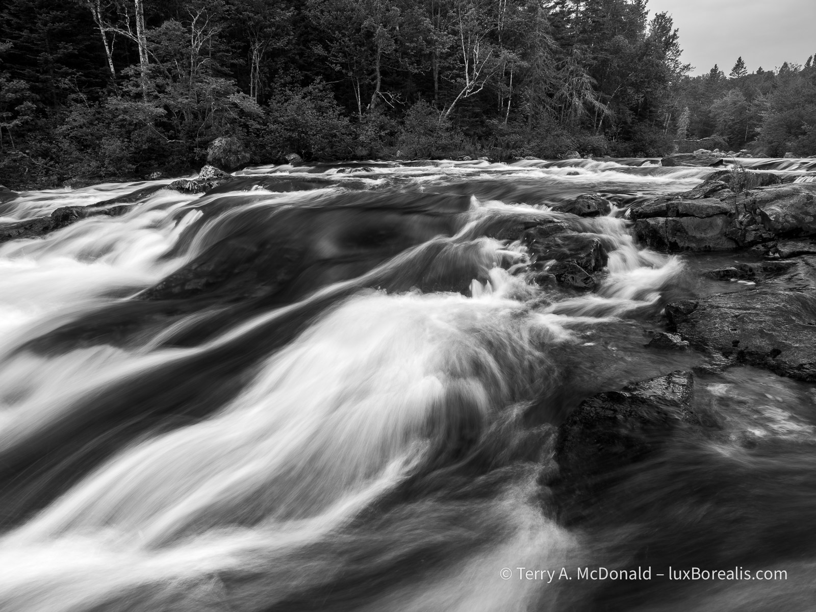
OM-1 w/ 12-100mm at 12mm (24mm efov); ƒ9 @ 1/2sec, ISO 800, LiveND 64; raw file processed in Lightroom.
Just a note on place names: in Québec, provincial parks such as Saguenay Fjord are called ‘national parks’; not to be confused with National Parks of Canada, such as . . .
Forillon National Park
It’s 5:30am, the beginning of day 8. Sunrise was at 4:14am, with the dawn chorus beginning sometime before that. Being in a tent, the soundscape was pleasurably overwhelming. I’d love to say I’ve been out shooting, but with an overcast sky, I decided to stay at our campsite, make coffee, and do some writing.
OM-1 w/ 12-100mm at 54mm (108mm efov); ƒ8 @ 1/1000, ISO 100, HHHR; raw file processed in Lightroom.
I’m finding the HHHR files to be wonderful for raising shadow areas without introducing noise—far better than shooting the same image as an HDR, which also seems to mute the colours somewhat.
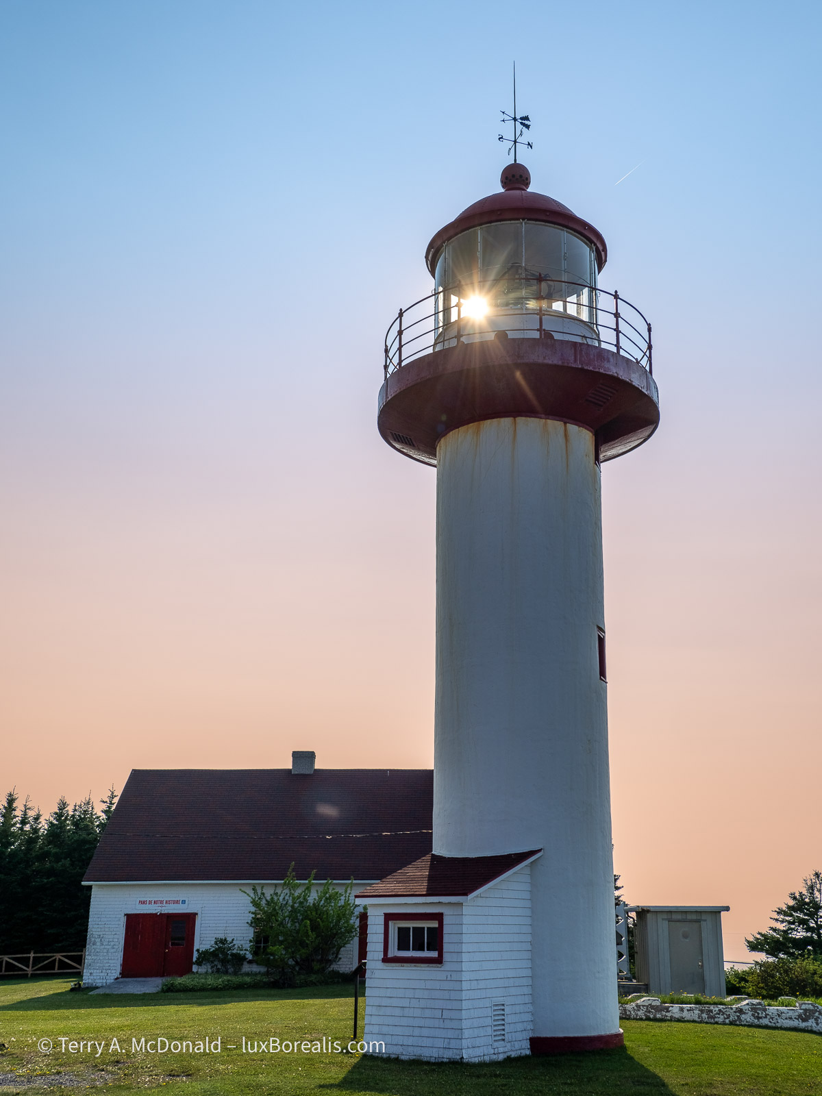
Forillon is a long drive from Saguenay—8 hours including the ferry. We crossed the St. Lawrence by ferry from Saint-Simeon to Rivière-du-Loup and continued on down the St. Lawrence to Gaspé. What a beautiful drive. We would have liked to stop for some of the unique architecture and colourful homes, but time was against us. We did stop for a couple of lighthouses, though.
OM-1 w/ 12-100 at 75mm (150mm efov); ƒ5.6 @ 1/640, ISO 200, HHHR; raw file processed in Lightroom.
OM-1 w/ 12-100mm at 18mm (36mm efov); ƒ5.6 @ 1/3200, ISO 200, HHHR; raw file processed in Lightroom.
The cliffs along the St. Lawrence are dramatic. But then, scattered along the coast are small villages with some agriculture, where ever a river had made its way down to the what is now, essentially, open ocean. Photographically, nothing seemed to work out well, so you’ll have to take my word for it.
Forillon itself is just as stunning. It’s the northern end of the Appalachian Highlands on mainland North America. The rock captures two significant mountain-building events—the Taconic orogeny, 450mya and the Acadian orogeny, 380mya—showing clearly with great arcs and diagonals of rock strata. Once as high as the Rockies, perhaps even higher, we now see the eroded remains of those mountains as the Appalachians.

These are the spectacular cliffs on the north side of Forillon.
OM-1 w/ 12-100mm at 100mm (200mm efov); ƒ5.6 @ 1/250, ISO 200, HHHR; raw file processed in Lightroom.
The same cliffs as shown above also provide nesting sites for thousands of sea birds: herring gulls, razorbills, guillemots, etc.
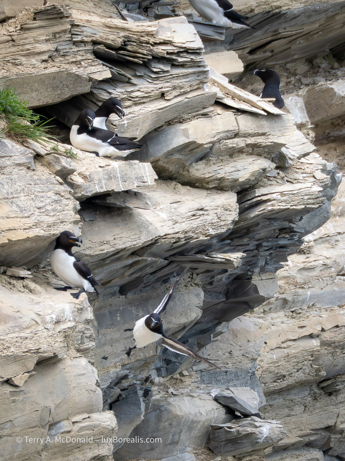
OM-1 w/100-400mm at 400mm (800mm efov); ƒ8 @ 1/1600, ISO 1600; raw file processed in Lightroom.
While photographing the death defying heights and flights, we were witness to a dramatic nest-robbing event by crows. After a few minutes of tormenting a razorbill pair at their nest, a crow picked up one of the eggs and tried to make off with it. Sadly, it ended up broken, spilling the contents and the developing embryo down the cliff face. You can see the egg breaking open in the lower left of the photo.
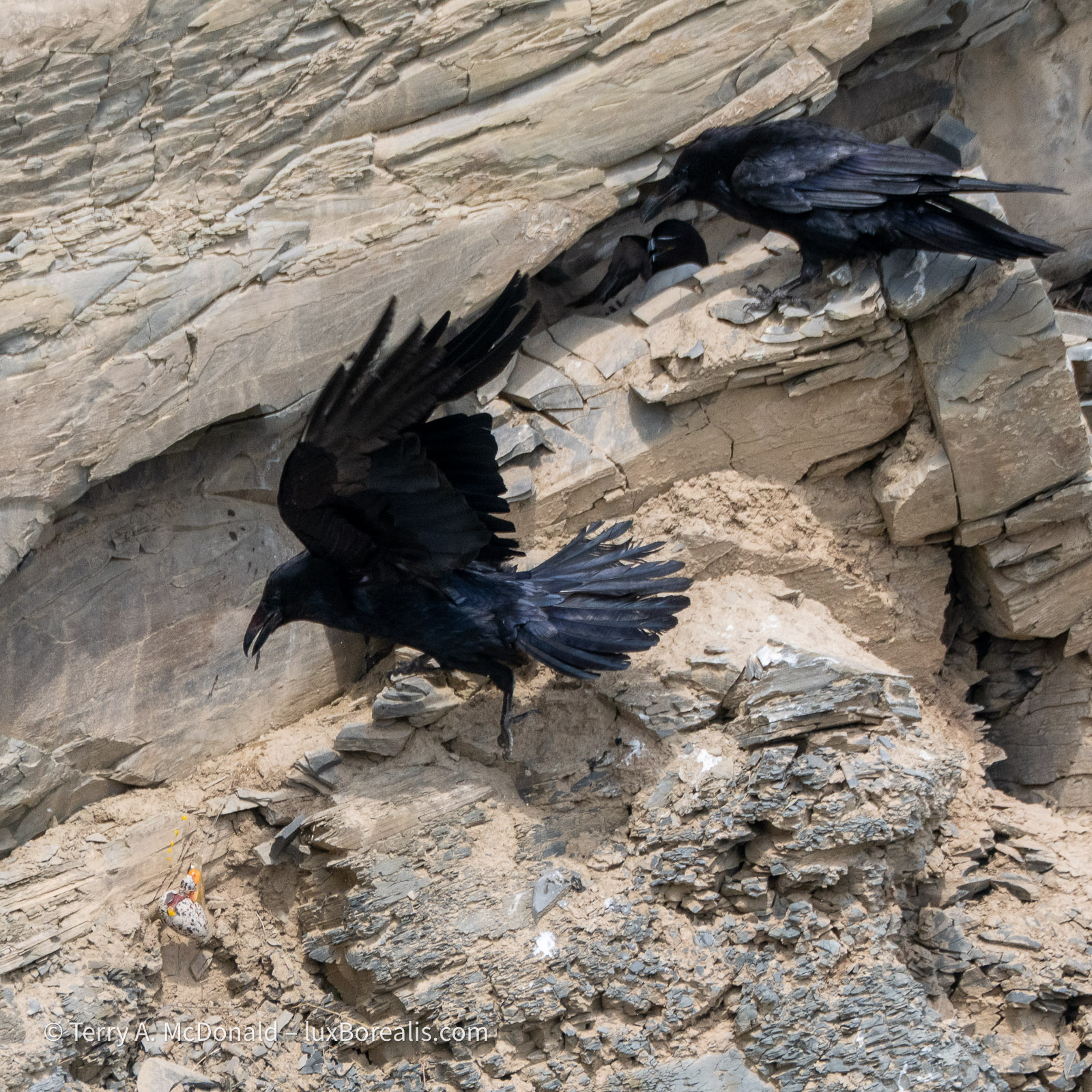
OM-1 w/ 100-400mm at 400mm (800mm efov); ƒ8 @ 1/1600, ISO 800; raw file processed in Lightroom.
In the afternoon, we took a wander down the ‘La Chute’ trail to see the waterfalls. Nice, but not overwhelming. Finally, I had an opportunity to use my tripod and TripodHR mode, providing an 80MP file. Often, tripods are not conducive to travel photography, as you are always on the go. I could have—and should have!—used it with the Riviére Noire photo above, but was being lazy. Those set-ups really deserved to be captured as 80MP files!
The rock strata in the area is diagonal, resulting from the uplift of the Appalachians, so my goal in photographing the falls was to preserve those diagonals in the flow of water.
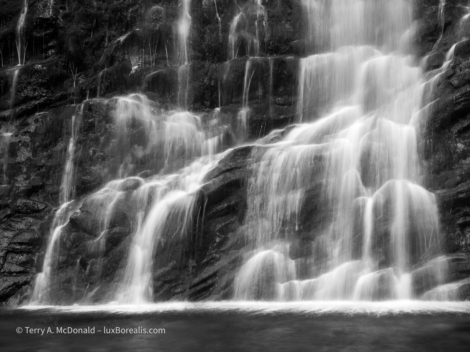
OM-1 w/ 12-100mm at 38mm (76mm efov); ƒ8 @ 1/10, ISO 100; TripodHR; raw file processed in Lightroom.
I promised myself earlier this year to make better use of a tripod, so I really must live up to that promise. I’m not sure Kouchibouguac National Park will offer the same opportunities, but I know for sure Mahone Bay, and after that Cape Breton Highlands National Park should offer some good coastal opportunities.
With a grey overcast and flat light, I must admit to not feeling creatively inspired for much of the rest of the day. I’m one who is drawn to the light, often looking for a subject to best take advantage of the light. So, when it turns dreary, I just don’t ’see’ much worth photographing.
OM-1 w/ 12-100mm at 50mm 9100mm efov); ƒ8 @ 1/50, ISO 100, HHHR; raw file processed in Lightroom.
As we drove back to Forillon from having a fish ‘n’ chips and poutine dinner, we became inundated by a low-hanging fog. I specifically used HHHR at a slow shutter speed to blur the waves while capturing a larger file size. Setting the ISO to 100 allowed for 1/50th rather than 1/100th providing a more even blur.
For now, it’s getting late and here in the far east of the Eastern Time Zone, the sun is rising awfully early, so I’ll turn in. Tomorrow is another long day of driving to Kouchibouguac National Park.
Thanks for reading! Be sure to leave a COMMENT, whether it’s a question about equipment, techniques or locations or just an observation to add to the discussion.
